
Wildlife corridors connect natural habitats, allowing animals to move freely between protected areas. These pathways are critical for species survival, helping animals access food, mates, and safer environments, especially as human development and climate changes disrupt ecosystems.
Here are seven key wildlife corridors across North America that play a vital role in maintaining biodiversity and reducing habitat fragmentation:
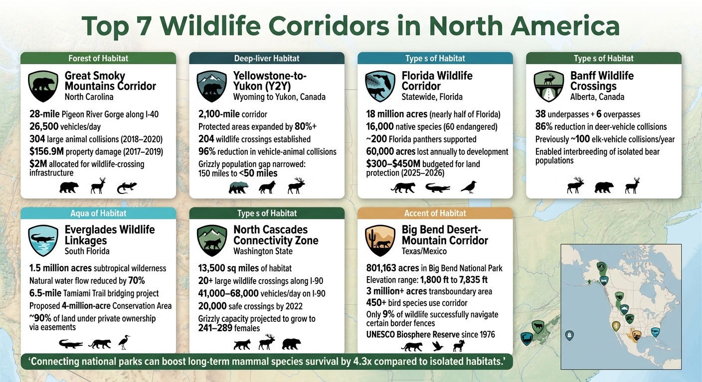
- Great Smoky Mountains Corridor: Links Great Smoky Mountains National Park to surrounding forests, addressing challenges like wildlife-vehicle collisions on I-40.
- Yellowstone-to-Yukon (Y2Y): A 2,100-mile corridor from Yellowstone to Canada’s Yukon, supporting species like grizzly bears and wolves.
- Florida Wildlife Corridor: Spanning 18 million acres, it protects habitats for Florida panthers, black bears, and other species.
- Banff Wildlife Crossings: Features 44 underpasses and overpasses along the Trans-Canada Highway, reducing animal-vehicle collisions by 86%.
- Everglades Linkages: Restores water flow and wildlife pathways in South Florida, benefiting species like the Florida panther and crocodiles.
- North Cascades Zone: A critical area in Washington State for grizzly bears, wolves, and lynx, with over 20 wildlife crossings along I-90.
- Big Bend Desert-Mountain Corridor: Connects diverse habitats in Texas and Mexico, providing migration routes for over 450 bird species and large mammals.
These corridors highlight the importance of connectivity in preserving wildlife and ecosystems. Solutions like wildlife crossings, conservation easements, and habitat restoration are key to ensuring their success.
Top 7 Wildlife Corridors in North America: Key Stats & Impact
We’re creating the world’s biggest wildlife corridor
sbb-itb-00512f3
1. Great Smoky Mountains Wildlife Corridors
The 28-mile Pigeon River Gorge along I‑40 serves as a crucial link between Great Smoky Mountains National Park, Pisgah National Forest, and Cherokee National Forest. However, this area – home to an incredible variety of wildlife – faces a significant challenge: I‑40, with approximately 26,500 vehicles traveling on it daily, has long been a major obstacle for animals moving between these protected spaces.
Species such as black bears, elk, white-tailed deer, and bobcats depend on safe crossing routes, while smaller creatures like box turtles and salamanders are also at risk. Between 2018 and 2020, researchers recorded 304 collisions between vehicles and large animals in the gorge alone. Statewide, North Carolina reported 56,868 wildlife-vehicle collisions between 2017 and 2019, leading to an estimated $156.9 million in property damage. These figures highlight the pressing need for solutions that protect both animals and drivers.
The Safe Passage coalition, established in 2017 and including organizations like the National Parks Conservation Association and Wildlands Network, has been working to address this issue. One example of their efforts is the Harmon Den Bridge on I‑40. This bridge was modified to include animal-friendly pathways along the creek beneath it, ensuring safer crossings. When Hurricane Helene caused the Pigeon River to surge from 4 feet to nearly 22 feet in September 2024, the reinforced bridge and its wildlife paths withstood the flooding, demonstrating the value of integrating smart design with ecological priorities.
With I‑40 already undergoing repairs and many North Carolina Department of Transportation (NCDOT) structures – averaging 60 years old – nearing the end of their service life, advocates see an opportunity to rebuild with dual goals in mind: flood resilience and improved wildlife connectivity. Ron Sutherland, Chief Scientist at Wildlands Network, summed it up well:
"If we build back with flood resilience in mind, we’ll also promote wildlife connectivity for species people care about."
Momentum is growing, thanks to both engineering innovations and legislative support. The North Carolina General Assembly has allocated $2 million to fund wildlife-crossing infrastructure in the gorge, including fencing and other proven measures. Meanwhile, a related initiative – the Safe Passage: I‑26 at the AT project – focuses on another critical area near Sams Gap, where 8,000 to 10,000 vehicles pass through daily, connecting Cherokee and Pisgah National Forests.
2. Yellowstone-to-Yukon Corridor
The Yellowstone-to-Yukon (Y2Y) Corridor plays a critical role in preserving migration routes and ensuring habitat connectivity. Stretching 2,100 miles from the Greater Yellowstone Ecosystem in the U.S. to Canada’s Yukon Territory, this initiative connects protected areas like Yellowstone, Glacier, and Banff National Parks through a network of public lands, private properties, and Indigenous territories. This vast corridor enables essential seasonal migrations and supports wildlife populations.
Research highlights the importance of linking these regions. For instance, connecting Yellowstone to Glacier National Park increases the survival chances of mammal species by 4.3 times compared to isolated parks. Species such as grizzly bears, wolves, elk, pronghorn, and mule deer rely on this connectivity to migrate between their summer and winter habitats. Yale University ecologist Arthur Middleton captures this dynamic beautifully:
"Megafauna, using their ancient corridors, flow back and forth, up and down mountains, between winter and summer range. They pulse through the landscape like heartbeats, pumping and recycling caloric energy."
The story of a wolf named Pluie underscores the need for such efforts. In the early 1990s, Pluie was tracked covering an astonishing 100,000 square kilometers (around 38,000 square miles) across Montana, Idaho, Washington, Alberta, and British Columbia – an area 15 times larger than Banff National Park. This journey inspired the launch of the Y2Y Conservation Initiative in 1993.
Since then, the initiative has made remarkable progress. Protected areas have expanded by over 80%, and 204 wildlife crossings have been established. These crossings, combined with fencing, have reduced vehicle collisions with animals like deer, elk, and moose by 96%. One of the most impressive achievements is the narrowing of the gap between grizzly bear populations in the Yellowstone ecosystem and those near Glacier National Park – from 150 miles to less than 50 miles.
Harvey Locke, founder of the Yellowstone to Yukon Conservation Initiative, sums it up:
"Parks work. But science began to teach us that parks could be improved on. For species like wolves and bears, who can migrate thousands of miles, parks are not enough."
3. Florida Wildlife Corridor
The Florida Wildlife Corridor stretches across 18 million acres – covering nearly half of Florida – and links the Everglades to areas bordering Georgia and Alabama. This expansive network connects national and state parks, forests, wildlife management zones, and private lands safeguarded by conservation easements.
The urgency for preservation is clear. Florida loses approximately 60,000 acres of habitat annually to development, and with the state’s population at 22.8 million in 2023, projections show it could surpass 33 million by 2070. Out of the corridor’s 18 million acres, 10 million are already protected, while the remaining 8 million – comprising unprotected farms, ranches, and wildlands – are at risk of future development. Alarmingly, up to 500,000 acres across ten counties could be lost by 2030.
This corridor is home to 16,000 native species, including 60 classified as endangered. It plays a critical role in supporting around 200 Florida panthers and a dense black bear population in the Ocala National Forest . By linking fragmented habitats, the corridor not only ensures genetic diversity for species like the Florida panther but also protects essential ecosystem functions such as water purification and flood mitigation. For instance, a conservation easement established in March 2022 at Lykes Ranch’s 11-mile Chaparral Slough created vital pathways for panthers expanding into northern territories.
Wildlife crossings, such as underpasses along Alligator Alley (I‑75), provide safe passage for panthers and other species. Tools like the Human Modification Index and the Omniscape algorithm help researchers identify "pinch points" – narrow, high-risk bottlenecks that make up just 1.6% of critical linkages but account for 57% of connectivity flow.
Thomas Hoctor and Reed Frederick Noss from the University of Florida emphasize the importance of this effort:
"The corridor is an ambitious conservation project. It provides sufficient habitat to sustain healthy wildlife populations while also protecting Florida’s key ecosystem services, including water quality and flood storage."
The state has demonstrated its commitment by allocating $300–$450 million in the 2025–2026 budget for land protection. Since the 2021 Act, over 300,000 acres have already been approved for conservation . These investments highlight Florida’s dedication to maintaining wildlife connectivity and ensuring the corridor remains a cornerstone of conservation efforts for years to come.
4. Banff Wildlife Crossings
Banff National Park in Alberta, Canada, holds the distinction of having the largest network of wildlife crossing structures in the world. The Trans-Canada Highway (TCH), once notorious for averaging about 100 elk-vehicle collisions annually, earned the grim nickname "The Meat Maker". To tackle this issue, Parks Canada implemented an extensive system of 38 underpasses and 6 overpasses, complemented by fencing to guide animals toward these safe passageways.
The results have been dramatic. Collisions involving deer have dropped by around 86%, and the crossings have reconnected habitats previously divided by the highway. Grizzly bears, wolves, cougars, lynx, elk, and deer are among the species utilizing this network. Interestingly, grizzlies tend to prefer overpasses, while black bears favor underpasses.
A DNA study using hair-snaring traps revealed something even more impactful: these crossings don’t just reduce roadkill – they allow isolated bear populations to interbreed. This genetic exchange is crucial for long-term species survival.
"Animals weren’t just using the crossings – they were relying on them to prevent genetic isolation." – Shannon Kelleher, Author/Reporter, Mongabay
Tony Clevenger, a senior wildlife research scientist, added:
"The focus at the beginning wasn’t about large carnivores or connectivity conservation. It was about protecting the motorists." – Tony Clevenger, Senior Wildlife Research Scientist, Western Transportation Institute
The Banff model’s success has inspired similar projects across the U.S., including on I-90 in Washington state and US-93 in Montana. Additionally, Parks Canada takes steps to limit human activity in key areas, such as requiring hikers to travel in groups of four or more in certain zones and enforcing seasonal closures. These measures ensure wildlife can use the crossings undisturbed.
5. Everglades Wildlife Linkages
Everglades National Park spans a massive 1.5 million acres of subtropical wilderness in South Florida. It’s also the only place on Earth where alligators and crocodiles share the same habitat. Historically, the Everglades ecosystem stretched across nearly 11,000 square miles. However, decades of drainage and development have reduced its natural water flow by about 70%. This fragmentation has made restoring wildlife linkages a critical mission, as continuous habitats are essential for the survival of many species.
One of the biggest challenges is the Tamiami Trail (U.S. Highway 41). This highway cuts across South Florida, blocking the natural flow of water from the central Everglades into the park. Instead of removing the road, efforts have focused on raising sections of it. A 6.5-mile bridging project has been underway, including a completed 1-mile stretch and a 2.6-mile extension launched in 2016. These elevated roadways aim to restore water flow and create pathways for wildlife.
"Bridging the trail literally means elevating strategic portions of the roadway above the wetlands, reconnecting wildlife habitat and allowing water that has been blocked for decades to flow freely."
- Cara Capp, Greater Everglades Associate Director, NPCA
Beyond the Tamiami Trail, the Western Everglades Restoration Project (WERP) targets the northwest region of the ecosystem. This initiative works across areas like the Seminole Tribe’s Big Cypress Reservation and Big Cypress National Preserve. Restoration efforts in corridors such as the L-28 Triangle and Mullet Slough involve activities like canal backfilling and levee modifications. These changes help restore ecological flow, directly benefiting species like the Florida panther, wood stork, Everglades snail kite, and American crocodile.
Looking ahead, the proposed Everglades to Gulf Conservation Area envisions a massive 4-million-acre corridor spanning 12 counties, from Lakeland to Big Cypress National Preserve. This ambitious plan depends heavily on conservation easements with private landowners, including ranches and citrus groves. Remarkably, about 90% of the land in this area is expected to remain under private ownership, protected through easements rather than federal acquisition. As Paul Gray, Science Coordinator for Audubon Florida, explains:
"A Florida panther can walk across a ranch and be relatively safe… But you can’t have them walking through neighborhoods without conflict."
These efforts bridge federally managed lands with private properties, creating safe pathways for wildlife while respecting the needs of working farms and ranches. It’s a practical approach to conservation in a landscape where large-scale federal land purchases aren’t an option.
6. North Cascades Connectivity Zone
Nestled in the Cascade Mountains of Washington State, the North Cascades Connectivity Zone acts as a vital link between the North Cascades, the Olympic Peninsula, and the Northern Rockies. This area plays a crucial role in maintaining landscape permeability, which allows wildlife to navigate regions fragmented by highways and human development. The 2025 Washington Habitat Connectivity Action Plan (WAHCAP) has designated this zone as one of 13 Connected Landscapes of Statewide Significance (CLOSS).
"Maintaining connected networks of lands and waters at statewide, regional, and local scales is essential to retaining resilient and healthy wildlife populations." – Washington Habitat Connectivity Action Plan
One standout project in this zone is the Snoqualmie Pass East Project along Interstate 90. Here, over 20 large wildlife crossing structures, including two major overpasses, have been constructed to help animals safely cross one of Washington’s busiest highways. With daily traffic ranging from 41,000 to 68,000 vehicles, I-90 had become a significant barrier to wildlife movement. However, by the end of 2022, WSDOT cameras recorded the 20,000th safe wildlife crossing at these structures. This included 5,959 elk, 12,068 deer, and 2,016 coyotes. In a remarkable event in August 2022, a moose used the Resort Creek underpass to cross I-90, traveling nearly 100 miles from its usual range. Shortly after, Mount Rainier National Park recorded its first-ever moose visitor. These efforts highlight the zone’s success in mitigating the impacts of highways on wildlife and maintaining ecological connectivity.
The zone also plays a key role in grizzly bear recovery efforts. In April 2024, the National Park Service and U.S. Fish & Wildlife Service finalized a Record of Decision to reintroduce grizzly bears into the North Cascades Ecosystem, an area covering roughly 13,500 square miles of mostly roadless mountains and forests along the U.S.-Canada border. Interestingly, climate modeling suggests that the quality of grizzly bear habitats in the North Cascades is expected to improve over time. Projections indicate that the carrying capacity for female grizzlies could increase from 139 to between 241 and 289 by the end of the century.
"All the models across every angle of combinations pointed toward high-quality grizzly bear habitat getting better." – Jason Ransom, Wildlife Biologist, North Cascades National Park
The planning and management of this connectivity zone rely heavily on data. WAHCAP’s connectivity mapping incorporates 10 key values, such as focal species functional connectivity, landscape permeability, and climate resilience. Additionally, the plan includes a Full Highway System Ranking, which evaluates every mile of Washington’s roadways based on their ecological barrier impact. This ranking helps prioritize locations for installing wildlife crossing structures.
7. Big Bend Desert-Mountain Corridor
Nestled in far west Texas, the Big Bend Desert-Mountain Corridor covers the 801,163 acres of Big Bend National Park and stretches across the U.S.–Mexico border into Chihuahua and Coahuila. This corridor showcases a dramatic range in elevation, from 1,800 feet along the Rio Grande up to 7,835 feet in the Chisos Mountains. These shifts in altitude connect the river corridor, the Chihuahuan Desert floor, and the high-elevation "sky island" forest, creating microhabitats with unique climates that support a wide variety of species.
The Chisos Mountains, which make up just 2% of the park, are home to relict forests of Douglas fir, quaking aspen, and Arizona pine – remnants of a time when the region was cooler and wetter. These forests, about 20°F cooler in summer than the surrounding desert, act as a refuge for species like black bears, mountain lions, and Carmen white-tailed deer. Additionally, the corridor plays a key role in migration, serving as a pathway for over 450 bird species traveling between North, Central, and South America.
"The Rio Grande corridor is also a migration highway for many species – passing through the desert." – National Park Service
Big Bend’s conservation influence extends well beyond the park’s boundaries. It anchors a transboundary protected area of over 3 million acres, linking Big Bend Ranch State Park in Texas with Mexico’s Maderas del Carmen and Cañón de Santa Elena reserves. This vast region was recognized as a UNESCO Biosphere Reserve in 1976.
However, the corridor faces serious challenges, with border infrastructure being the most pressing. A study in Frontiers in Ecology and Evolution revealed that only 9% of observed wildlife successfully navigated certain stretches of border fencing. Researchers from Texas A&M and Sul Ross Universities are tracking mountain lions and black bears to understand how these barriers affect their movements. According to Ph.D. student Chloe Nouzille, one mountain lion “either bounced away from the barrier system or traced alongside it until it could find a place to go around”. Conservation advocate Scott Nicol highlighted the broader issue:
"As that corridor is repeatedly fragmented, the bits of habitat… that become isolated are less and less likely to be able to remain viable, and their biodiversity decreases."
Comparison Table
Here’s a quick look at five key wildlife corridors, summarizing their location, habitat types, primary species, and conservation roles.
| Corridor | Location | Habitat Type | Primary Species | Conservation Role |
|---|---|---|---|---|
| Yellowstone-to-Yukon (Y2Y) | Wyoming to Yukon, Canada | Rocky Mountain forest, alpine tundra, and grasslands | Grizzly bear, gray wolf, wolverine | Expands habitat for large mammals and supports species adapting to climate changes |
| Florida Wildlife Corridor | Statewide, Florida | 81 distinct natural communities, including wetlands, uplands, and forests | Florida panther, Florida black bear, Florida grasshopper sparrow | Protects about 16,000 native species and provides critical ecosystem services like water filtration and flood control |
| Banff Wildlife Crossings | Alberta, Canada (along Trans-Canada Highway) | Rocky Mountain forest and riparian zones | Grizzly bear, wolf, elk, cougar | Introduced wildlife overpasses and underpasses to reduce road-related animal deaths |
| Everglades Wildlife Linkages | Southwest Florida (Big Cypress Swamp area) | Wetlands, swamps, and dry prairies | Florida panther, Florida black bear | Serves as the core breeding habitat for the panther and supports northward migration to prevent habitat fragmentation |
| North Cascades Connectivity Zone | Washington State/British Columbia | Old-growth forest, subalpine meadows, and river valleys | Grizzly bear, gray wolf, lynx | Facilitates access to seasonal food for grizzlies in the North Cascades |
This comparison highlights the unique conservation goals and challenges tied to each corridor. For example, while the Florida Wildlife Corridor and Everglades Wildlife Linkages share geographic overlap, their purposes differ – one ensures broad connectivity across ecosystems, while the other focuses on specific breeding grounds for the Florida panther. Similarly, the Y2Y Corridor and North Cascades Connectivity Zone both aid grizzly bear populations but operate on vastly different scales.
These efforts underscore how conservation strategies are tailored to regional needs. From addressing road-related animal deaths in Banff to countering urban development pressures in Florida, each corridor plays a critical role in preserving wildlife movement, genetic diversity, and ecosystem health across North America.
Conclusion
In North America’s national parks, wildlife corridors are much more than lines on a map. They’re the lifelines of ecosystems, enabling animals to find mates, reach food sources, and adjust to environmental changes. Without these pathways, isolated wildlife populations face serious challenges like genetic decline, increased mortality, and shrinking habitats.
Connecting major national parks through these corridors can make a massive difference. Research shows that such connections can boost the long-term survival of mammal species by 4.3 times compared to fragmented habitats. That’s often the line between survival and extinction.
The key to keeping these corridors functional lies in proactive conservation. Building wildlife crossings, securing private lands through easements, and addressing critical bottlenecks are far more effective than trying to fix the damage after development has already taken place. Protecting these linkages before they’re cut off is crucial.
Each corridor discussed here demonstrates how linking habitats creates tangible benefits for wildlife. These efforts are the product of collaboration among agencies, landowners, and communities. Maintaining this connectivity is not a one-time effort – it’s an ongoing commitment to preserving the integrity of wild landscapes.
FAQs
How do wildlife corridors help prevent species decline?
Wildlife corridors help protect animal populations by creating safe pathways between habitats. These routes are crucial for migration, ensuring animals can move freely without being cut off by human developments. They also promote genetic diversity by enabling species to interbreed, which strengthens populations and reduces the risk of genetic disorders. Additionally, these corridors help species adapt to changes in their environment, offering a lifeline as ecosystems shift. By connecting habitats, wildlife corridors play an essential role in preserving biodiversity and supporting the health of ecosystems.
What makes a wildlife crossing effective on busy highways?
Wildlife crossings play a crucial role in reducing collisions between vehicles and animals while addressing habitat fragmentation. These crossings typically include multiple structures, fencing, and ecological bridges. Together, they create safe routes for animals to navigate busy roadways, promoting both their safety and the uninterrupted flow of ecosystems.
How can private landowners help protect wildlife corridors?
Private landowners have a unique opportunity to support wildlife by safeguarding critical corridors. One way to do this is through conservation easements, which restrict development and protect habitats for the long term. Additionally, adopting habitat management practices – like installing wildlife-friendly fencing or restoring natural landscapes – can make a big difference. Partnering with land trusts is another effective approach to connect and maintain these natural areas, ensuring animals have safe paths to travel and uninterrupted habitats to thrive.