
If you want to see nature take back places people left behind, these 10 sites make the point fast. I’m looking at ghost towns, mine camps, cliff dwellings, and old villages across the U.S. In each one, the same story shows up: people built them, people left, and weather, plants, sand, snow, and time kept moving.
Here’s the short version:
- I found 10 sites spread across forests, deserts, lake dunes, cliffs, and high country
- The time span runs from about 600 CE to towns lived in until the 1970s and 1992
- Some are easy roadside stops, while others take a long drive, a trail, or a remote trip
- The main risks are simple: unstable buildings, mine hazards, wildlife, and closed areas
- If you visit, the rule is the same everywhere: stay on marked paths and leave artifacts in place . For specific safety updates or trail conditions, you can ask our park information chatbot
What stands out to me is the contrast. At Elkmont, chimneys and stone steps sit under thick trees. At Rhyolite and Joshua Tree, wind and dust wear down old mining remains. At Mesa Verde and Hovenweep, old stone work faces sun, wind, and slow erosion. And at Bodie and Kennecott, cold, height, and time do much of the damage.
You’re not just looking at ruins. You’re looking at two timelines at once: when people used these places, and how the land has been pulling them back.
Quick Comparison
| Site | Setting | Main ruin type | Main signs of nature taking over | Access |
|---|---|---|---|---|
| Elkmont | Forest | Logging town/resort | Chimneys, foundations, trees closing in | Easy trail access |
| Rhyolite | Desert | Gold town | Dust, wind, worn stone, rust | Easy drive |
| Kennecott | Alaska mountains | Copper mine town | Snow, ice, weather damage | Remote |
| Blue Heron | Appalachian forest | Coal camp | Rot, forest growth, site outlines | Road or railway |
| Glen Haven | Lake dunes | Lumber/steamboat village | Sand, wind, weather wear | Easy access |
| Boston Township | Wooded valley | Village remains | Overgrowth on roads and homesites | Trail access |
| Joshua Tree ruins | Desert | Mines, ranches, homesteads | Sun, wind, desert plants | Mixed access |
| Mesa Verde | Cliff alcoves | Puebloan dwellings | Weathering in exposed areas | Tours/overlooks |
| Hovenweep | Mesa and canyon rims | Puebloan towers | Wind, sun, light plant growth | Self-guided trails |
| Bodie | High desert | Gold town | Split wood, rust, grass, animal use | Road access |
So if you’re choosing where to go, you can plan your national park trip by sorting them this way: forest ruins, desert ruins, cliff ruins, and mining ruins. That makes it easier to match the trip to what you want to see.
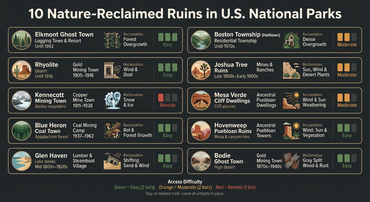
10 Nature-Reclaimed Ruins in U.S. National Parks: At a Glance
What Makes These Ruins Worth Visiting
These sites show two timelines at once: how people once used them, and how nature moved back in. That push and pull is what makes them so interesting.
A big part of the draw is decay itself. Moss, rust, broken timbers, and roots pull these structures back into the land. What you get is a place that feels damaged, but still very much alive.
Abandonment also sparks curiosity. You can’t help wondering what happened here, who left, and why.
Some of these places make you work for the view with a long walk or steep climb. That effort can make the visit feel even more memorable.
In some cases, the ruins now serve as wildlife habitat too. That living layer adds even more depth to the experience.
With that in mind, the sites below show reclamation across forests, deserts, cliffs, and old mining country. Here are 10 of the clearest examples.
sbb-itb-00512f3
1. Elkmont Ghost Town
Type of Ruin
Elkmont is one of the clearest places in the Smokies to see a town slowly disappear into the woods. It began as a logging town and later became a resort community in what is now Great Smoky Mountains National Park. Today, the area is preserved as the Elkmont Historic District. A handful of cabins are still standing, but much of what remains is quieter than that: stone chimneys, old fireplaces, and building foundations sitting under the forest canopy.
Historic Era
Elkmont changed more than once over time. It started with pioneer farming, then shifted into a Little River Lumber Company boomtown during the logging years, and later became a resort community that lasted until 1992. When the land joined Great Smoky Mountains National Park in 1934, residents did not leave at once. Many stayed through lease agreements that remained in place until those leases ended in 1992.
Visible Natural Reclamation
The forest has done most of the editing here. Many wooden buildings are gone, while the stone parts remain: chimneys standing alone among the trees, foundations with no walls around them, and stone stairways that lead to empty space. This is especially easy to spot in the Society Hill area.
Visitor Access and Safety Notes
Visitors can reach the site by way of the Little River Trail, which starts near the Elkmont campground. The National Park Service keeps 17 cabins in the district, and some are open for self-guided tours. The restored Appalachian Clubhouse, kept in its 1930s appearance, is also open to visitors.
A simple rule applies here: if a structure is posted, treat it as unsafe and stay in cleared areas.
2. Rhyolite and Death Valley Mining Ruins
Type of Ruin
Rhyolite shows, in plain sight, how fast a boomtown can fall apart. This former gold rush town in the Death Valley region was once busy and full of life. Now, what’s left is stark and dusty: weathered foundations, rusted shacks, and crumbling stone ruins slowly being taken back by the desert. Wind and dust keep creeping across the ground, little by little reclaiming the site.
Historic Era
Gold was discovered here in 1905, and the town hit its peak between 1905 and 1916.
Visible Natural Reclamation
The desert is steadily swallowing what remains. Wind and dust are burying the town’s last structures, while weathered foundations and rusted shacks still trace the old roads through the site.
Visitor Access and Safety Notes
Rhyolite is one of the easier ghost towns to visit in the Death Valley region. It’s about a 45-minute drive from the Furnace Creek Visitor Center. If you go, watch for snakes and stay out of unstable buildings. From the desert, the list next shifts to a remote copper camp in the mountains.
3. Kennecott Mining Town
Type of Ruin
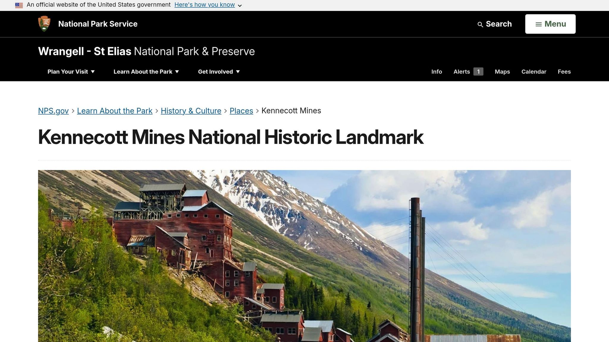
Kennecott is an abandoned copper mine and mill town in Wrangell–St. Elias National Park and Preserve. It sits beside a glacier in remote Alaska, and the place still holds onto its huge mill along with several old company-town buildings.
Historic Era
Copper was found here in 1900. The mine ran from 1911 to 1938 and, at its peak, supported as many as 600 workers.
Visible Natural Reclamation
The alpine climate keeps chipping away at the site. Snow, ice, and time have worn down many parts of it, and some structures now survive only through stabilized, arrested decay.
Visitor Access and Safety Notes
Do not enter any structure unless it is clearly marked as open to visitors. From Alaska’s ice, the list moves to a desert boomtown slowly reclaimed by wind and dust.
4. Blue Heron Coal Town
Type of Ruin
Blue Heron, also known as Mine 18, is an abandoned coal mining camp in the Big South Fork National River and Recreation Area in Kentucky. The Stearns Coal and Lumber Company ran the site.
Historic Era
Mining here lasted from 1937 to 1962. After that, the camp was abandoned and slowly fell apart.
Visible Natural Reclamation
The mix of Appalachian humidity and steady forest growth wore the town down over time. Wooden homes and storefronts rotted away, board by board, until little was left.
To help visitors picture what once stood there, the National Park Service installed open steel frames in the exact spots where the buildings used to be. Now those skeletal outlines sit among the trees, tracing the town’s old footprint in a simple, striking way.
Visitor Access and Safety Notes
Visitors can get to Blue Heron by car or by taking the Big South Fork Scenic Railway from Stearns, Kentucky. The Blue Heron Loop Trail runs 6.5 miles through the site.
From Kentucky’s coal country, the list moves next to another landscape where ruins are being pulled back into the land.
5. Sleeping Bear Dunes Ghost Town Sites
Type of Ruin
The list moves from Kentucky’s coal country to Michigan’s shoreline, where wind and sand are slowly taking the land back.
Inside Sleeping Bear Dunes National Lakeshore in Michigan sits Glen Haven, first founded in the mid-1800s as Sleeping Bearville. It started as a lumber village and steamboat stop, centered on a 300-foot dock where vessels came to pick up wood for their engines. At its high point, the town had a sawmill, inn, school, and wagon shop.
Historic Era
Glen Haven began to fade in the 1920s, when better highways pulled travelers away from the water routes that had kept the town alive. The Great Depression sped up that decline. In the 1970s, the National Park Service bought the land to protect what was left of the village.
As travel changed, the town lost its place and sat more exposed to the dunes that now shape the site.
Visible Natural Reclamation
Today, Glen Haven rests behind shifting dunes that are pushing it back into the landscape. Wind, sand, and rough weather have worn down the remaining buildings, though the NPS has steadied some of the main structures. Visitors can still spot the blacksmith shop, remains of the dock, and the cannery, which now serves as a boat museum.
6. Boston Township "Helltown" Remnants
Type of Ruin
Boston feels different from a lot of abandoned places. Instead of sitting out in the open, it hides under thick woods in Cuyahoga Valley National Park. The village was first settled in 1806, then largely emptied after federal land acquisition in the 1970s. That long fade from lived-in town to quiet forest is what led to the nickname "Helltown."
The clearest piece still standing is Boston Cemetery, where some headstones date to the early 1800s. Beyond that, what remains is more subtle: overgrown foundations, traces of old homesites, and the closed section of Stanford Road often called the "Road to Nowhere."
Historic Era
Most of the village’s buildings were demolished over time. The last major teardown was completed in 2016.
Visible Natural Reclamation
Nature has moved back in hard here. Dense underbrush and mature trees now cover old roads and former house lots. In summer, much of the site slips behind the foliage. When winter strips the trees bare, foundations and other traces are easier to spot.
Visitor Access and Safety Notes
You can start at Stanford Road Trailhead or the Boston Mill Visitor Center, where rangers provide maps.
A few basics help:
- Bring a paper map
- Wear waterproof boots during muddy seasons
- Stay off private property near the cemetery
7. Joshua Tree Mine and Ranch Ruins
Type of Ruin
In the desert, change happens at a slower pace. But you can still see it. Joshua Tree National Park preserves scattered homesteads, ranch ruins, mine remains, and abandoned vehicles from the park’s early settlement era.
Visible Natural Reclamation
Wind, sun, and desert plants have worn these remains down and softened their edges. Over time, many of these sites have started to blend into the land around them, which makes them easy to overlook. A lot of them sit away from the main trails, so they don’t jump out at you the way ruins in other places might.
Visitor Access and Safety Notes
The National Park Service treats these sites as fragile pieces of history. That means visitors should not collect artifacts, enter mine openings, or go near unstable structures.
From these scattered desert remains, the list turns to the preserved cliff dwellings of Mesa Verde.
8. Mesa Verde Cliff Dwellings
Type of Ruin
Mesa Verde National Park in Colorado is home to Ancestral Puebloan cliff dwellings built into steep rock faces and natural alcoves. These homes were shaped to match the cliff face itself.
Historic Era
The dwellings were abandoned around 1300 CE.
Visible Natural Reclamation
Mesa Verde looks different from the more overgrown places on this list. Here, nature works through weathering and concealment more than plant growth. Because the dwellings sit inside natural alcoves, the cliff gives them some shelter. At the same time, wind, sun, and time keep wearing down the parts left exposed.
From these sheltered cliff homes, the list moves to Hovenweep, where ruins sit exposed on open mesa land.
9. Hovenweep Puebloan Ruins
Type of Ruin
Unlike Mesa Verde’s sheltered alcoves, Hovenweep’s ruins sit out in the open on canyon rims and broad mesas. The site holds ruins built by the Ancestral Puebloans, including stone towers and dwellings set on canyon edges and in alcoves. These buildings were made for defense and built to last. More than 700 years later, many are still standing.
Historic Era
Ancestral Puebloans lived here for centuries.
Visible Natural Reclamation
This is high desert country, and the ruins take the full hit of it. Weathering and creeping vegetation slowly wear down the stonework. Because the site is so exposed, wind, sun, and plant growth put extra stress on the ruins.
Visitor Access and Safety Notes
Stay on marked trails and view the ruins only from designated areas. That helps protect both visitors and these fragile historic structures. Photography is allowed, but do not disturb or collect artifacts.
10. Bodie Ghost Town
Type of Ruin
After Hovenweep’s open mesas, the list shifts to another bare, wind-beaten place where time and weather do the work bit by bit.
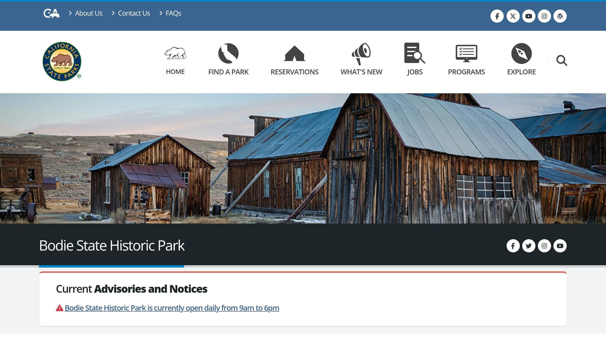
Bodie is a 19th-century gold-mining ghost town in California’s high desert, east of the Sierra Nevada, at 8,375 feet. It is preserved in arrested decay: stabilized, not restored.
Historic Era
Bodie hit its peak during the gold rush era in the late 1800s. Thousands of miners and settlers poured in, chasing gold, and the town later emptied as the ore ran out.
Visible Natural Reclamation
You can see the slow wear everywhere. Wooden siding has turned gray and split apart, rusted mining equipment still sits where it was left, and grass pushes up through the floorboards of abandoned homes. Wildlife now lives inside some of the empty buildings too.
Visitor Access and Safety Notes
Stay on marked paths and do not enter closed buildings. When planning your visit, use a national park budget planner to manage travel costs.
Side-by-Side Comparison of All 10 Sites
Here’s a quick look at all 10 sites, based on setting, ruin type, age, and how easy they are to visit.
| Site | Park, land manager, or park unit | Ruin Type | Era of Primary Use | Main Reclamation Features | Access Notes |
|---|---|---|---|---|---|
| 1. Elkmont Ghost Town | Great Smoky Mountains National Park (NPS) | Logging town & resort community | Resort use through 1992 | Stone chimneys, isolated foundations, roofless cabin shells | Trail access; self-guided tours for preserved structures |
| 2. Rhyolite | Near Death Valley National Park (BLM land) | Gold mining town | 1905–1916 | Weathered foundations, rusted shacks, crumbling stone walls | ~45-minute drive from Furnace Creek Visitor Center |
| 3. Kennecott Mining Town | Wrangell-St. Elias National Park and Preserve (NPS) | Copper mining & processing mill | 1911–1938 | NPS-stabilized mill building; snow and ice wear on structures | Remote; unpaved McCarthy Road or shuttle required |
| 4. Blue Heron Coal Town | Big South Fork National River and Recreation Area (NPS) | Coal mining town | 1937–1962 | Steel outline frames where rotted buildings once stood; coal tipple remains | Accessible by scenic railway or road |
| 5. Glen Haven | Sleeping Bear Dunes National Lakeshore (NPS) | Logging & steamboat stop | Mid-1800s to 1920s | Shifting dunes encroaching on structures; weathered blacksmith shop and dock remnants | Easily accessible within the lakeshore |
| 6. Boston Township (Helltown) | Cuyahoga Valley National Park (NPS) | Residential township | Occupied until the 1970s | Dense overgrowth over former roads and homesites; overgrown foundations | Accessible via park trails and roads |
| 7. Joshua Tree Mine and Ranch Ruins | Joshua Tree National Park (NPS) | Gold mining & ranching | Late 1800s to early 1900s | Wind-worn adobe walls, rusted mining machinery, eroding stone foundations | Accessible via various park trails, including the Desert Queen Mine trail |
| 8. Mesa Verde Cliff Dwellings | Mesa Verde National Park (NPS) | Ancestral Puebloan dwellings | ~600–1300 CE | Wind and sun weathering on exposed stonework; cliff-sheltered decay | Guided tours required for entry; overlook views available |
| 9. Hovenweep Puebloan Ruins | Hovenweep National Monument (NPS) | Ancestral Puebloan towers | 1200s | Weathering and creeping vegetation on exposed canyon-rim stonework | Self-guided trails around canyon rims |
| 10. Bodie Ghost Town | Bodie State Historic Park (State-managed) | Gold mining town | 1870s–1940s | Arrested decay; gray split siding, rusted equipment, grass through floorboards | Road-accessible; state park entrance fee required |
The sharpest difference here is access. Rhyolite and Glen Haven are simple visits, while Kennecott takes real effort to reach.
The time span is just as striking. These places run from Mesa Verde, with use beginning around 600 CE, all the way to Boston Township, where people still lived into the 1970s. That range gives the list a very different feel from site to site – some read like deep history, while others feel almost close enough to touch.
Conclusion
From forests and deserts to cliffs and old mining camps, the pattern stays the same: people built, people left, and nature never stopped moving. Timber rots. Iron rusts. Regrowth covers what used to feel permanent, until only chimneys, foundations, and a few scattered fragments remain.
That’s what gives these places their pull. They show, in plain terms, that nature outlasts human structures. They also stick with people because they show both human ambition and its limits at the same time. For that reason, they deserve careful, low-impact visits.
If you go, stay on marked trails, take photos, and leave everything where it is. Removing even small artifacts can carry criminal penalties under federal law. The best visit is the one that leaves the ruins untouched.
FAQs
Which ruin is easiest to visit?
The easiest picks here are the ruins at the River Road East intersection in Big Bend National Park and the ghost town of Rhyolite.
The ruins in Big Bend National Park make for a quick stop if you’re already heading to Hot Springs or Rio Grande Village. Rhyolite is also simple to visit, sitting about a 45-minute drive from the Furnace Creek Visitor Center.
Terlingua is another easy stop, especially if you want to wander at your own pace with a self-guided tour.
Are these ruins safe to explore?
It depends on the site and the park’s official rules. Some ruins have marked trails and managed access. But plenty of abandoned structures are unstable, with collapsing floors, exposed nails, and broken glass.
For safety, stick to designated paths, follow posted closures, don’t climb on ruins, and leave historic items where you find them.
What should I never do at these sites?
Never disturb or collect historic items. Follow posted signs, stay within trail boundaries, and respect closures meant to protect both visitors and these fragile, sometimes hazardous structures.
Stick to designated paths, keep tripods off delicate surfaces, leave nothing behind, and stay out of off-limits areas.