
Great Sand Dunes is harder than it looks. Sand can take 2–3x more energy than a normal trail, the park starts at 8,200 feet, and summer sand can hit 150°F.
If I were picking a hike fast, I’d do it like this:
- Want a short walk? Try Montville Nature Trail or Dunes Overlook
- Want to climb sand? Go for First Ridge or High Dune
- Want the biggest dune day? Pick Star Dune
- Want shade and firm footing? Choose Mosca Pass
- Visiting in summer? Start before 10:00 AM or wait until after 5:00 PM
- See clouds or strong wind? Get off the dunes
The main point: pick your route by time, heat, wind, and how much sand you want to deal with. A short dune climb can feel much longer than the mileage suggests, while foothill trails give you cooler air, marked paths, and steadier ground.
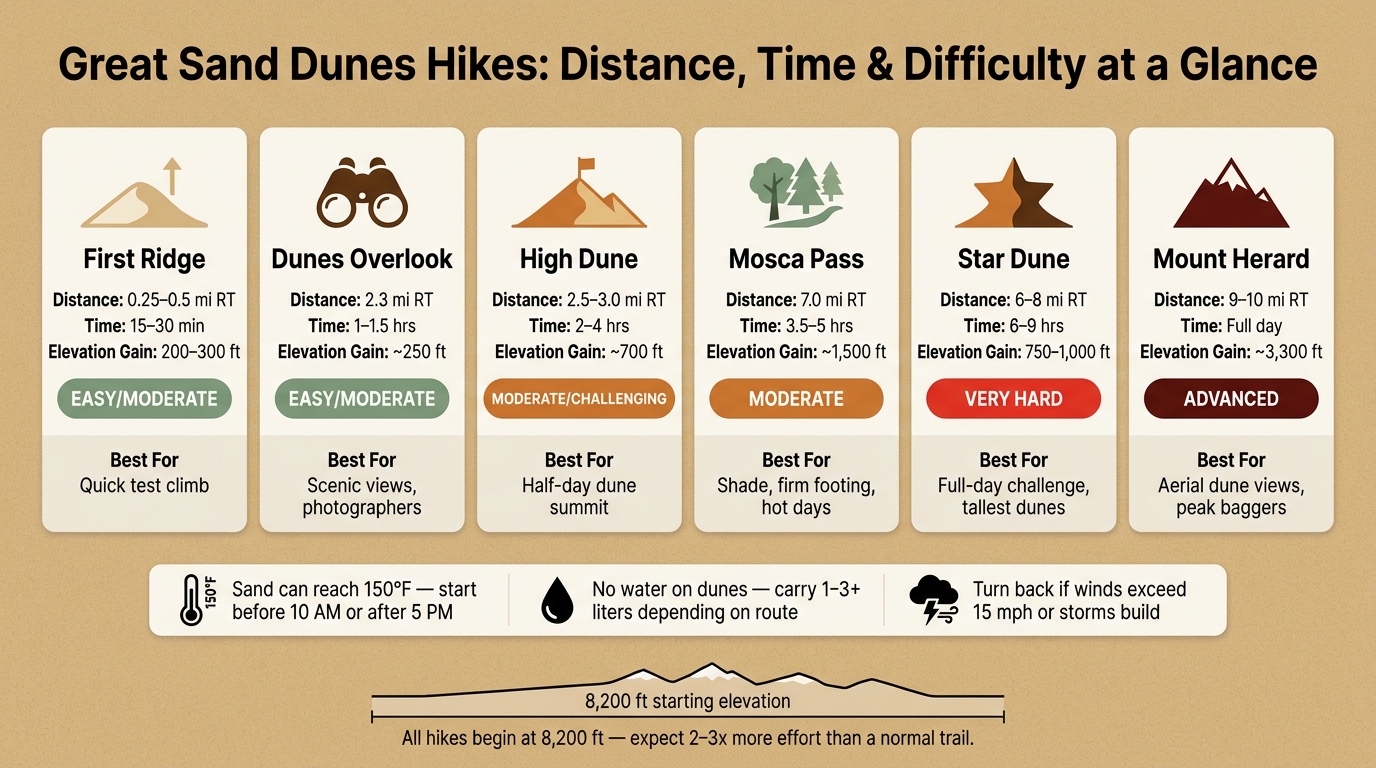
Great Sand Dunes Hikes: Distance, Time & Difficulty at a Glance
146: Exploring Great Sand Dunes National Park: Best Tips + Activities
sbb-itb-00512f3
Quick Comparison
| Hike | Distance (RT) | Time | Main Draw | Best Use |
|---|---|---|---|---|
| First Ridge | 0.25–0.5 miles | 15–30 min | Fast sand climb | Short test hike |
| Dunes Overlook | 2.3 miles | 1–1.5 hrs | Big views without deep sand | Easy scenic walk |
| High Dune | 2.5–3.0 miles | 2–4 hrs | Main dune goal for many people | Half-day dune climb |
| Star Dune | 6–8 miles | 6–9 hrs | Long sand route to a top dune | Full-day hard hike |
| Mosca Pass | 7 miles | 3.5–5 hrs | Shade, creek, firm trail | Hot or windy days |
I’d treat this guide as a simple filter: easy viewpoints, dune climbs, and cooler foothill trails, with safety rules built around heat, water, wind, and storms.
Short Hikes and Easy Viewpoints
Short trails give you dune views without the grind of a full sand climb. They’re your best bet if you want scenery, a bit of shade, or a quick walk without heading deep into the sand. If you’re after more effort and bigger dune views, jump to the dune climbs in the next section.
Sand Sheet Loop and Montville Nature Trail
The Sand Sheet Loop is a very short interpretive walk near the Visitor Center. It’s a good pick for a quick first look at the park’s ecology.
If shade matters more, go with Montville Nature Trail. This 0.5-mile loop takes about 30 minutes and climbs through cottonwoods and piñon trees, with views over the dunes and Mt. Herard. It’s an easy option for families or for getting out of the heat later in the day.
Dunes Overlook and Wellington Ditch Trail
Both trails start near Piñon Flats Campground and stay on firm ground.
Dunes Overlook is 2.3 miles round trip and usually takes about 1 to 1.5 hours. It gains about 250 feet and opens up broad views of the dunefield and the San Luis Valley. Near sunset, the sand turns bronze and the mountains pick up alpenglow.
Wellington Ditch Trail is a 3.4-mile round trip moderate hike. It passes through vegetation and gives you dune views without leaving solid ground.
Use the table below to compare distance, shade, and effort.
| Trail | Distance (RT) | Effort | Best For | Shade |
|---|---|---|---|---|
| Sand Sheet Loop | Very short | Easy | Quick intro, first-timers | Low |
| Montville Nature Trail | 0.5 miles | Easy | Families, heat relief | High |
| Dunes Overlook | 2.3 miles | Easy/Moderate | Scenic views, photographers | Partial |
| Wellington Ditch | 3.4 miles | Moderate | Longer walks | Partial |
How to Choose an Easy Hike
Pick Montville if you want shade. Choose Dunes Overlook if you want the best short hike for views. Go with Wellington Ditch if you want a longer walk on solid ground. For actual sand climbing, the next section gets into the dune routes.
Dune Climbs: From First Ridge to Star Dune
If the easy viewpoints don’t feel like enough, these are the main sand climbs to know.
The dunefield spans about 30 square miles, so it helps to choose a goal that matches your fitness, available time, and ability to stay oriented once you’re out on the sand.
First Ridge and High Dune
First Ridge is the fastest test climb. It’s about 0.25 to 0.5 miles round trip, with 200 to 300 feet of gain, and usually takes 15 to 30 minutes.
High Dune is the standard target for many visitors. Expect 2.5 to 3.0 miles round trip, about 700 feet of gain, and roughly 2 to 4 hours.
The easiest way to climb High Dune is to stick to the ridgelines instead of heading straight up a slope. Sand along the ridges is firmer, so each step tends to hold better. If you charge up a steep face, you can slide back 6 to 12 inches with every step, and that drains your legs in a hurry.
Also, watch for false summits. More than once, what looks like the top turns out to be just another rise.
Star Dune and Longer Sand Routes
Star Dune is a much bigger outing. At about 736 to 750 feet, it’s the second-tallest dune in North America. You won’t see it from the parking lot, which throws some people off right away.
To get there, hike about 2 miles south along the Medano Creek bed until its pyramid shape appears, then follow a ridge to the summit. The full trip is about 6 to 8 miles round trip with as much as 1,000 feet of elevation gain. If you’re not used to the 8,200-foot base elevation and thinner air, set aside up to 9 hours.
| Destination | Distance (RT) | Time Estimate | Elevation Gain | Difficulty |
|---|---|---|---|---|
| First Ridge | 0.25–0.5 miles | 15–30 min | 200–300 ft | Easy/Moderate |
| High Dune | 2.5–3.0 miles | 2–4 hours | ~700 ft | Moderate/Challenging |
| Star Dune | 6–8 miles | 6–9 hours | 750–1,000 ft | Very Hard |
How to Navigate the Dunes Safely
Getting back is often harder than heading out. Footprints disappear fast, so use landmarks instead.
- Turn around often and memorize the parking lot, Visitor Center, and Sangre de Cristo Mountains.
- Carry offline maps or GPS with the parking lot pinned.
- Set a turnaround time before 10:00 AM in summer and stick to it.
If the heat starts ramping up or the wind picks up, move to the cooler foothill trails in the next section.
Foothill and Mountain Trails for Cooler Conditions
When the dunes start baking or the wind turns nasty, the park’s foothill and mountain trails make a smart pivot. They offer firmer ground, more shade, and marked routes, which feels like a different world from the open dunefield. If you want less sun, steadier footing, or a hike that skips deep sand, start here.
Mosca Pass Trail
Mosca Pass Trail is the top pick for a shaded mountain hike with solid footing. It covers 7 miles round trip with about 1,500 feet of elevation gain, topping out at 9,737 feet. Most hikers should plan for 3.5 to 5 hours, depending on pace.
The trail follows Mosca Creek through aspen and evergreen forest, so it stays cooler than the dunes. Regular hiking boots or trail runners work well on this route. If you want a tougher high-country hike with bigger views, Medano Lake and Mount Herard are the next move.
Sand Ramp Trail
Sand Ramp Trail is a 22-mile backcountry access route that cuts through sandy foothill woodland. It’s much better for overnight travel than a day hike. Planning to camp out? You’ll need a free wilderness permit, which you can pick up at the Visitor Center.
Medano Lake, Mount Herard, and Backcountry Planning
If you’re after the park’s hardest climbs, this is where things get serious. Medano Lake and Mount Herard demand more planning, more effort, and a clean weather window.
Medano Lake starts at 10,000 feet and climbs about 2,000 feet over roughly 4 miles one way. Mount Herard reaches 13,297 feet and gives you an aerial view of the entire dunefield. The hike runs about 9 to 10 miles round trip with roughly 3,300 feet of gain. Both are tough climbs.
Getting to either trailhead means driving Medano Pass Primitive Road, and that road calls for a high-clearance 4WD vehicle. It can also close due to snow or risky creek crossings, especially in spring. In July and August, afternoon thunderstorms can build fast, so a dawn start gives you the best shot at finishing before the weather turns.
| Trail | Round Trip | Elevation Gain | Difficulty | Key Note |
|---|---|---|---|---|
| Mosca Pass | 7 miles | ~1,500 ft | Moderate | Shaded, creek-side |
| Sand Ramp Trail | 22 miles total | Varies | Moderate/Hard | Backcountry access; sandy terrain |
| Medano Lake | ~8 miles | ~2,000 ft | Hard | 4WD required to reach trailhead |
| Mount Herard | ~9–10 miles | ~3,300 ft | Advanced | Highest peak in the preserve |
Sand Walking, Heat, Wind, and Safety Basics
Once you pick a route, these basics can make the hike a lot easier and help you stay out of trouble. Walking on sand takes much more energy than hiking on a firm trail, especially at 8,200 feet.
How to Walk on Sand With Less Effort
Don’t charge straight up a loose dune face. It feels like progress for about 10 seconds, then the sand slides you back and steals your energy.
A better move is to angle up steep slopes in a zigzag pattern along ridgelines, where the sand is firmer and you avoid that constant backward slide on loose sand. On the way down, step lightly downhill and let the soft sand take some of the impact.
Short routes can also fool you. A climb that looks close can take much longer than expected, so efficient footing matters even more on longer dune hikes.
Footwear, Water, and Sun Protection
Sand surface temperatures can hit 150°F by midday in summer. That’s hot enough to burn feet or dog paws in minutes. Before you step out, press your hand flat against the sand. If you can’t keep it there for five seconds, it’s too hot.
For footwear, keep it simple:
- Use closed-toe shoes or boots for dune climbs
- Wear trail runners during cool mornings and evenings
- Save sandals for Medano Creek
At 8,200 feet, UV exposure is intense, and glare bouncing off the sand can wear out your eyes fast. Wear a UPF-rated long-sleeve shirt, lightweight pants, sunglasses, and sunscreen.
There are zero water sources on the dunefield, so you need to carry all of your water. Plan for at least 1–2 liters for a 2–4 hour hike and 3+ liters for longer routes like Star Dune.
Wind, Storms, and When to Turn Around
Heat isn’t the only thing to watch. Wind can wipe out landmarks and turn an easy return into a navigation mess. Afternoon thunderstorms are common in summer, and the open dunefield has no shelter.
If you hear thunder or see dark clouds building over the Sangre de Cristos, head down right away. If you notice static crackling or your hair starts standing up, seek shelter immediately.
Gusts over 15 mph can create blinding conditions and erase footprints almost at once. That’s the kind of wind that can shift a manageable hike into a route-finding problem, so treat it as a hard stop.
Turn around if:
- Half of your water is gone
- Dark clouds start building
- Strong gusts make landmarks hard to see
- You feel dizzy or nauseated
Conclusion: Picking Your Great Sand Dunes Hike by Time, Effort, and Conditions
The right hike here comes down to three things: how much time you have, how much work you want to put in, and what the weather is doing that day. Your main options fall into three buckets: short viewpoints, dune climbs, and cooler foothill trails.
Use this quick summary to line up the hike with your time, effort, and the day’s conditions.
| Hike | Distance (RT) | Time | Best For |
|---|---|---|---|
| First Ridge | 0.25–0.5 miles | 15–30 min | Quick test climb |
| Dunes Overlook | 2.3 miles | 1–1.5 hrs | Scenic viewpoint |
| High Dune | 2.5 miles | 2–4 hrs | Most visitors who want a summit and wide views |
| Star Dune | 6–8 miles | 6–9 hrs | Experienced hikers seeking the tallest dunes |
| Mosca Pass | 7.0 miles | 3–5 hrs | Shade seekers, forest scenery, and firm footing |
Longer sand routes take more out of you, especially at elevation. At 8,200 feet, even short dune hikes can feel longer than they look on paper, so it makes sense to match the distance to your fitness and bring enough water.
Fall is the best season for longer dune hikes. Start early or go later in the day to avoid heat, burned feet, and lightning.
When conditions shift – midday heat, building clouds, or winds above 15 mph – move to Mosca Pass or the Montville Nature Trail, and get off the dunes if storms build or winds pick up. The best route is the one that fits the day’s heat, wind, and the time you actually have.
FAQs
Which Great Sand Dunes hike is best for beginners?
For beginners, the Montville Nature Trail is a great pick. It’s a short, 30-minute loop with scenic views of the dunes and mountains, and you won’t have to deal with tough sand climbs.
If you want to actually step onto the dunes, the hike to the first ridge is a solid place to start. It usually takes 15–30 minutes and gives you a feel for walking on sand. You can take in the landscape, snap a few photos, and then decide if you’re up for a longer trek.
When is the best time of day to hike the dunes?
Early morning, especially at dawn, is the best time to hike the dunes. The sand is cooler and more packed down, so the walk feels a lot easier. You also miss the worst of the heat.
In summer, sand temperatures can hit 150°F. That can lead to heat exhaustion and badly burned feet. If you go later in the day, wait until after 6:00 p.m. when the sand starts to cool off. Just be careful – afternoon thunderstorms and lightning can still be a problem.
How much water should I bring for a dune hike?
There are no water sources in the dunefield, so you need to bring all the water you’ll use.
For shorter hikes like High Dune, pack at least 1 to 2 liters per person. For longer, tougher hikes like Star Dune, bring 2 to 4 liters per person.
The high altitude, dry air, and strong sun can wear you down fast. It’s smart to carry more water than you think you’ll need and start drinking before you feel thirsty.