
If I only had one day at the South Rim, I’d plan around light and access first. This route covers 14 stops from west to east, with the best sunrise picks near Mather, Yavapai, and Yaki, the best sunset picks around Hopi, Mohave, Pima, and Desert View, and the strongest river views at Desert View, Lipan, Grandview, Maricopa, and Pima.
Here’s the short version:
- I’d allow 8–10 hours for all 14 stops
- I’d allow 3–5 hours for a shorter visit
- I’d arrive before 9:00 AM to avoid parking trouble near the Visitor Center
- I’d use the shuttle for Hermit Road and Yaki Point
- I’d skip Pipe Creek Vista first if I needed to cut a stop
- I’d check closures before going, since Lipan Point is closed through December 23, 2026
- I’d remember that Hermit Road is closed to private cars from March 1 to November 30, 2026
- I’d remember that Yaki Point is shuttle-only all year
The list includes: Mather Point, Yavapai Point, Hopi Point, Powell Point, Maricopa Point, Mohave Point, Pima Point, Hermit’s Rest, Pipe Creek Vista, Yaki Point, Grandview Point, Moran Point, Lipan Point, and Desert View.
What matters most is simple: the same overlook can look flat at noon and far better early or late. So I’d treat this as a day plan, not a checklist.
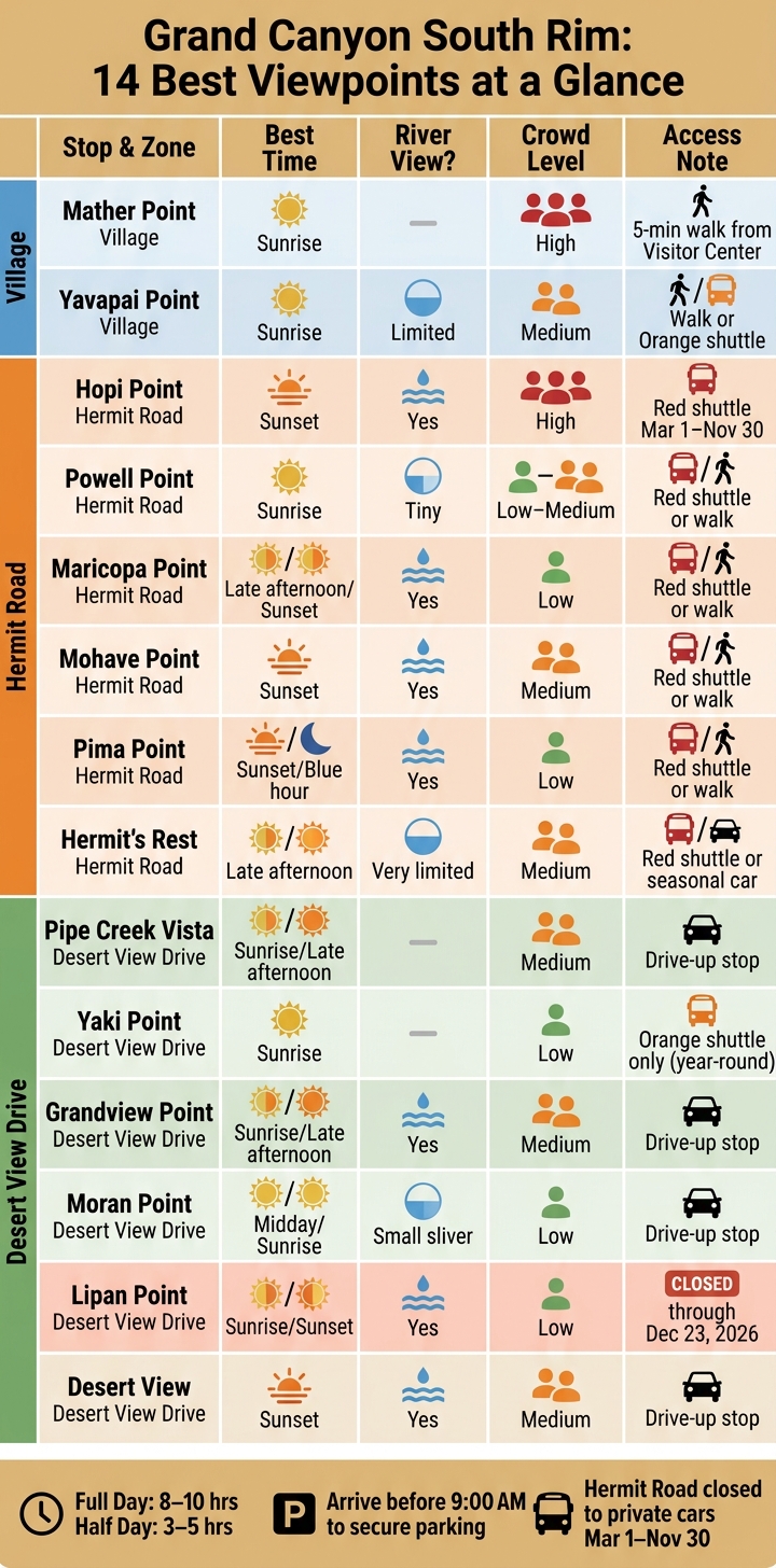
Grand Canyon South Rim: 14 Best Viewpoints at a Glance
Grand Canyon South Rim Best Viewpoints Tour – 21 Points!
sbb-itb-00512f3
Quick Comparison
| Stop | Best Time | River View | Crowd Level | Access Note |
|---|---|---|---|---|
| Mather Point | Sunrise | No | High | Short walk from Visitor Center |
| Yavapai Point | Sunrise | Limited deep canyon view | Medium | Walk or Orange shuttle |
| Hopi Point | Sunset | Yes | High | Red shuttle Mar 1–Nov 30 |
| Powell Point | Sunrise | Tiny river view | Low-Medium | Red shuttle or walk |
| Maricopa Point | Late afternoon / sunset | Yes | Low | Red shuttle or walk |
| Mohave Point | Sunset | Yes | Medium | Red shuttle or walk |
| Pima Point | Sunset / blue hour | Yes | Low | Red shuttle or walk |
| Hermit’s Rest | Late afternoon | Very limited | Medium | Red shuttle or seasonal car access |
| Pipe Creek Vista | Sunrise / late afternoon | No | Medium | Drive-up stop |
| Yaki Point | Sunrise | No | Low | Orange shuttle only |
| Grandview Point | Sunrise / late afternoon | Yes | Medium | Drive-up stop |
| Moran Point | Midday / sunrise | Small river view | Low | Drive-up stop |
| Lipan Point | Sunrise / sunset | Yes | Low | Closed through 12/23/2026 |
| Desert View | Sunset | Yes | Medium | Drive-up stop |
If you want the short takeaway: start early, park once, use the shuttle where needed, and pick stops by light instead of trying to do every overlook.
What to Know Before You Visit: South Rim Layout, Shuttles, and Driving Rules
The South Rim is split into three main zones. Once you know which viewpoints belong to each one, the day gets a lot easier and far less confusing.
South Rim zones at a glance
The South Rim has three main zones:
- Village area: Visitor Center, Mather Point, Yavapai Point, and the Bright Angel Trailhead. This is the easiest area to reach on foot or by shuttle.
- Hermit Road: 7 miles west. This includes Hopi Point, Mohave Point, Pima Point, and Hermits Rest. Access changes by season.
- Desert View Drive: About 25 miles east. This includes Grandview Point, Moran Point, Lipan Point, and Desert View. There is no free shuttle service here.
These zones also explain the stop order used in the route below.
Where private cars are not allowed
Two parts of the South Rim have strict vehicle rules, so it helps to plan ahead.
Hermit Road is closed to private vehicles from March 1 through November 30, 2026. During that period, you’ll need to use the Hermit Road Shuttle or join a commercial tour.
Yaki Point has a separate rule that stays in place all year. Private cars are not allowed, and motorized access is limited to the free Kaibab Rim (Orange) shuttle. You can also walk or bike there. If you have mobility needs, you can ask for a Scenic Drive Accessibility Permit at entrance stations or visitor centers.
From December 1 through the end of February, private vehicles are allowed on Hermit Road because the shuttle does not run. Yaki Point, though, stays shuttle-only unless you’re going by foot or bicycle.
Parking, shuttle timing, and short walks
Parking near the Visitor Center fills up fast. Between 10:00 AM and 4:00 PM, getting a spot near Mather Point is especially hard, especially in summer. The simplest move is to arrive before 9:00 AM, park once, and use the free shuttle system for the rest of the day.
In summer, the Hermit Road (Red) shuttle runs every 8 to 15 minutes. The Kaibab Rim (Orange) shuttle starts as early as 5:00 AM, which helps if you’re heading to Yaki Point for sunrise. That setup makes it pretty easy to start at one end and move along the rim without doubling back.
You can save time by mixing shuttle rides with short walks on the Rim Trail instead of waiting at every stop. The paved Rim Trail connects many viewpoints in the Village area and along Hermit Road across 13 mostly flat miles. Mather Point to Yavapai Point is 0.7 miles, or about a 15-minute walk. Powell Point and Hopi Point are also close enough to walk between without much trouble.
With the layout sorted out, the stops below follow that same west-to-east order.
How to Use This 14-Stop South Rim Route
Keep the shuttle zones and access rules in mind, then follow the route in this order to line up each stop with the best light. The day starts in the Village for sunrise, shifts west along Hermit Road through the morning, and ends on Desert View Drive for late-afternoon color.
That order isn’t random. It follows the way light moves across the South Rim, and that changes what you see.
Why this route runs west to east
East-side stops pick up sunrise color early. Hermit Road’s west-facing overlooks tend to look better in morning light. Later in the day, Desert View Drive often gives you stronger late-afternoon color.
If you’re taking photos, this matters a lot. The same overlook can feel flat at one time of day and look dramatic a few hours later. Matching each stop to the light can make a big difference in both the view and your shots.
Full-day route vs. half-day visit
Seeing all 14 stops takes 8–10 hours. If you only have part of a day, plan on 3–5 hours. In that case, the best move is to focus on the Village area plus either Hermit Road or Desert View Drive.
Use the table below to pick the version that fits your schedule.
| Visit Type | Time Needed | Zones Covered | Best For |
|---|---|---|---|
| Full-day route | 8–10 hours | Village + Hermit Road + Desert View Drive | First-timers who want the complete picture |
| Half-day visit | 3–5 hours | Village + one scenic drive | Travelers on a tight schedule |
How to cut the list down
If you need to trim stops, a few are easy to swap out.
- Mohave Point overlaps a lot with Hopi Point, which is only 0.4 miles farther and gives you a better sunset composition.
- Maricopa Point and Powell Point look so similar that one is usually enough.
- Pipe Creek Vista is the easiest stop to skip.
For mobility or accessibility needs, the paved Rim Trail between Mather and Yavapai is the simplest choice. It’s fully paved and wheelchair accessible.
If your main goal is photography, pick Yavapai Point over Mather for sunrise. Its north-northeast angle lets early light hit the canyon walls more directly, which leads to stronger color.
1. Mather Point
Mather Point is the first stop on this west-to-east route and one of the easiest places to start at sunrise if you’re near the Visitor Center. It’s only a 5-minute walk from the Grand Canyon Visitor Center, and once you reach the railing, the view opens into a 180-degree panorama. On a clear day, you can see as far as 60 miles to the west. That makes it a simple first stop before the route heads farther west.
You won’t see the Colorado River from Mather Point, but you can spot Phantom Ranch.
This spot gets crowded fast. Crowds peak between 10:00 AM and 4:00 PM, and the overlook can draw several hundred people at a time. A July 2025 field report counted just six people at 5:40 AM, then noted heavy crowding by 11:00 AM. If you want space at the railing, plan to arrive 30–45 minutes before sunrise. You’ll have a much better shot at a quiet view and those first bands of golden light on the canyon walls.
"Colder morning temperatures and the difficulty of rising early frequently result in fewer people at canyon viewpoints." – National Park Service
If you want to keep moving, a flat Rim Trail walk heads west to Yavapai Point. It’s about 0.7 miles one way. From there, the route continues west to Yavapai Point.
2. Yavapai Point
Yavapai Point is about 0.7 miles west of Mather Point on the paved Rim Trail. It tends to feel calmer, mostly because tour buses don’t stop here. You can walk over from Mather Point or take the free Kaibab/Rim (Orange) shuttle, which runs all year and arrives every 15 minutes starting 30 minutes before sunrise. So if you’re moving west from Mather Point, this is the next stop that makes the most sense.
Easy access is only part of the draw. At sunrise, Yavapai Point is one of the best spots on the South Rim. Its north-northeast-facing view catches direct light on the far canyon walls, which helps bring out more depth and texture in the landscape. The panorama runs from Havasupai Point in the west all the way to Desert View in the east, and it reaches deep into the inner canyon.
If you want a short extra stop, head into the Yavapai Geology Museum to see the 3D relief model and the rock-layer displays. After that, you can keep going on the paved Trail of Time, a 2.83-mile section of the Rim Trail where each meter stands for one million years of geologic history. From here, continue west to Hopi Point.
3. Hopi Point
Next up on Hermit Road, Hopi Point is the South Rim’s top sunset stop. It sticks farther out into the canyon than the other Hermit Road overlooks, which gives you a 270-degree panoramic view stretching 25 miles in both directions. That position matters at sunset. Light can hit both canyon walls at the same time instead of lighting up just one side.
From the rim edge, you can also see five stretches of the Colorado River. Big formations like the Isis, Horus, and Osiris Temples stand out from here too. In late light, that broad angle works in your favor.
For photos, point your camera east or straight into the canyon. After sunset, the alpenglow often turns the walls pink or orange for about 10 minutes.
This spot gets busy. On summer evenings, 200 to 300 visitors gather at Hopi Point for sunset. Get there 60 to 90 minutes early. If the main viewing platform feels packed, walk south along the rim for a quieter view.
Getting there is pretty simple:
- From March 1 through November 30, Hopi Point is open by the free Hermit Road (Red Route) shuttle, or by foot or bicycle.
- The shuttle runs after sunset, so you can stay for the light and ride back.
- Private vehicles are allowed only from December through February.
If you want a short extra walk, the paved Rim Trail links Hopi Point to Powell Point, which makes for a quieter Rim Trail add-on.
4. Powell Point
Just east of Hopi Point, Powell Point is a quieter overlook with strong morning light and fewer people around. There’s also a memorial nearby for John Wesley Powell, whose expeditions gave the point its name.
Powell Point is a good pick for sunrise because the east-facing view gets direct light on the canyon walls. If you want a few minutes to get set up and take it in, get there at least 30 minutes before sunrise.
"Only the sharpest eye will be able to spot the tiny patch of River that gave Powell such hardship." – National Park Service
For photos, the lower viewing area usually gives you a cleaner angle across the canyon and toward distant features like Isis and Shiva Temples. The river is barely visible from here. The Rim Trail connects Powell Point west to Hopi Point and east to Maricopa Point. From here, continue east to Maricopa Point.
5. Maricopa Point
A short walk east of Powell Point, Maricopa Point gives you the first clear look at the Colorado River along Hermit Road. The overlook extends about 100 feet out from the rim before the canyon drops away.
This is the first stop on Hermit Road where the river comes into view. Just below the overlook, you can spot the remains of the Orphan Lode Mine, a former copper and uranium mine that produced rich uranium ore until 1967. Stay on the trail. Old mine remnants are still nearby.
Maricopa Point faces west and opens up to a broad 180-degree view, which makes it a strong pick for late-day photos. It also marks a nice shift in the drive: the broader, sunrise-friendly overlooks are behind you, and the deeper canyon views start to take over from here. Keep an eye out for the Battleship, Tonto Trail, and Bright Angel Trail.
Another plus: this stop usually stays pretty quiet, even when Hopi Point gets crowded. If Hopi Point is jammed at sunset, Maricopa Point is a calmer option with a similar end-of-day feel.
The Rim Trail connects Maricopa Point west to Powell Point. From here, you can continue east to Mohave Point.
6. Mohave Point
Next up on Hermit Road, Mohave Point is a west-facing sunset stop with a straight shot 3,000 feet down to Salt Creek, Granite, and Hermit rapids.
If you want sunset views without the bigger crowds at Hopi Point, this is often the better pick. Mohave usually gets about 60–80 visitors, while Hopi Point tends to draw 200–300.
Plan to arrive 30–45 minutes before sunset. The first 10 minutes after sunset often bring the strongest color.
Mohave sits about 0.8 miles east of Hopi Point on the paved Rim Trail, and the trail keeps going 1.1 miles east to Pima Point. From here, continue east to Pima Point.
One thing to know: there are no restrooms at Mohave Point. The nearest restrooms are at Hopi Point, 0.8 miles west. From March 1 through November 30, you can get here by shuttle, foot, or bike only.
7. Pima Point
East of Mohave Point, Pima Point gets the same sunset glow with fewer people around. It’s one of the quietest overlooks on Hermit Road, and one of the best spots to see – and sometimes even hear – the Colorado River. On calm days, the sound of Granite Rapids can bounce up the canyon walls.
The view reaches about 40 miles across the canyon. You can spot 94 Mile Creek and the Temple Buttes fading into the distance. Look west to see the Cataract Plains, a flat plateau shaped by erosion long before the canyon took its current form, and use the rapids below as a strong foreground for photos. From here, Hermit’s Rest is the next stop to the east.
Because it faces west, Pima Point is a great place for sunset and a quieter pick than Hopi Point. Try to get there about 40 minutes before sundown. That’s usually when the canyon walls start shifting from gray to warm orange. Then stick around for blue hour, about 20 to 30 minutes after sunset, when the rock faces take on softer color. Even then, it usually stays less crowded than Hopi Point.
The paved Greenway Trail runs 1.1 miles east to Hermit’s Rest and works well for wheelchairs, strollers, and bikes. From March 1 through November 30, you’ll need to use the Hermit Road shuttle, walk, or bike. From December through February, private vehicles are allowed here.
8. Hermit’s Rest
After Pima Point, Hermit’s Rest marks the western end of Hermit Road. The view from the rim is pretty limited here because trees block much of it, and you can barely see the Colorado River. If your main goal is a stronger canyon view, Pima Point is the better nearby stop.
Still, Hermit’s Rest is well worth a visit for the building itself. Mary Colter designed this 1914 stone structure to resemble a rustic miner’s cabin, with a huge fireplace and a front stone archway topped by a hanging bell. The building is also a National Historic Landmark.
"Mary Colter, one of Grand Canyon’s most famous architects, built Hermits Rest in 1914 to look like an old miner’s cabin, complete with a giant fireplace and front porch." – National Park Service
If you’re taking photos, late afternoon or sunset is a good time to shoot the stone archway and fireplace. Hermit’s Rest also has the only year-round water bottle-filling station on Hermit Road, which makes it a smart place to refill before hiking or biking back.
You’ll also find:
- A snack bar
- A gift shop
- Restrooms
For experienced hikers, the Hermit Trail starts about 0.5 miles west of the shuttle stop. It’s steep, unmaintained, and meant for backcountry travel. One more detail that matters: the last return shuttle leaves one hour after sunset and only stops at Hermit’s Rest, Pima, Mohave, and Powell Points on the ride back. From here, the route continues east to Pipe Creek Vista.
9. Pipe Creek Vista
From Hermit’s Rest, the drive turns east onto Desert View Drive. Pipe Creek Vista sits at 7,160 feet on Desert View Drive at Mile Marker 242.5. It’s the first scenic pullout east of the South Entrance Road junction.
This stop gives you a 180-degree view across the Pipe Creek drainage, with Mather Point on the west side and Yaki Point on the east. This is not the place to chase a river shot. Your eye should go to the drainage itself, the hoodoos, the distant temples, and the darker patches along the canyon floor.
Light matters here. Sunrise and late afternoon usually give the scene more shape and depth, while midday light can make the canyon look flat. If you want a cleaner photo and a more open rim angle, walk about 0.2 miles west of the main overlook.
Late morning through mid-afternoon is when the crowds start to stack up, and the parking lot fills fast. If you pull in and there’s no room, save yourself the hassle and keep driving east to Duck on a Rock or Twin Overlooks.
If you feel like stretching your legs, the paved Rim Trail links this stop with nearby viewpoints. It’s wheelchair-accessible and bike-friendly, and it runs:
- 0.8 to 0.9 miles east to South Kaibab Trailhead
- 1.3 to 1.4 miles west to Mather Point
In summer, the Kaibab/Rim (Orange) shuttle stops here every 12 minutes from 9:00 a.m. to 5:00 p.m..
Warm afternoon thermals also make this a good spot to look for California condors. If you’ve got binoculars, bring them.
10. Yaki Point
East of Pipe Creek Vista, Yaki Point brings the drive back to a sunrise-first stop. It sits at 7,262 feet on a narrow peninsula that sticks out into the canyon, so you can look down both canyon walls as the sun comes up. At sunrise, the first light hits both sides of the canyon at the same time, which is why many people see it as one of the South Rim’s top sunrise overlooks.
One big plus: private cars can’t go to Yaki Point. That keeps it much quieter than busy spots like Mather or Yavapai. In fact, it’s usually much quieter than Mather Point.
To get there, take the free Kaibab/Rim (Orange) shuttle. It starts early enough for sunrise and runs late enough for sunset. That early schedule makes Yaki one of the easiest sunrise stops on the South Rim. If you’re going for sunset instead, show up early. The sun drops behind the foreground plateau fast, and the light changes in a hurry.
For photos, Yaki Point gives you a wide 270-degree panorama, open views of the South Kaibab Trail below, and the Desert View Watchtower as a far-off silhouette to the east. One thing missing from this overlook: you won’t get a direct view of the Colorado River.
If you feel like stretching your legs, the nearby South Kaibab Trailhead leads to Ooh Aah Point. The round trip is 1.8 miles, and the hike back up is steep, but the view below the rim feels like a whole different world.
In fall, Yaki Point also works as a hawkwatch site for migratory raptors. From here, continue east on Desert View Drive.
11. Grandview Point
Next up on Desert View Drive, Grandview Point sits at about 7,400 feet and is roughly 10.2 miles east of Grand Canyon Village. It’s also the southernmost point on the South Rim.
This stop gives you one of the first eastbound chances to spot the Colorado River from the South Rim, with several bends visible off to the east. You can also pick out Horseshoe Mesa and buttes like the Rama, Vishnu, Shiva, and Krishna temples.
Sunrise is the best time to be here if you want the nicest light on the river bends and Horseshoe Mesa. Late afternoon is also a good pick. If you want fewer people, go early. Crowds are heaviest from 10 AM to 3 PM, which also happens to be when the light looks the flattest.
If trees block part of the main overlook, walk a short way down the Grandview Trail. Even a brief drop puts you below the tree line and opens the view. Just note that the full trail is steep and unmaintained.
If you want something quieter, Shoshone Point is a nice side option. It’s a flat 1-mile walk on a shaded dirt road that leads to an almost 360-degree overlook. From there, keep heading east to Moran Point.
12. Moran Point
East of Grandview Point, Moran Point marks a quieter part of Desert View Drive. It’s one of those stops that feels a bit more tucked away, and you’ll need a car to get there since the free shuttle doesn’t serve it.
Getting to the overlook is simple. A short paved path runs from the parking area to a level viewing platform with guardrails. Once you’re there, head to the end of the point for the best view angles. And if you want even more room to breathe, the small pullouts between Moran and Lipan can give you rim views with hardly anyone around.
If you like geology, this stop has a lot going on. Moran Point is named after Thomas Moran, the 19th-century American landscape painter whose work helped build public support for protecting the Grand Canyon. Below the rim, Red Canyon shows off Hakatai shale in red and orange bands, while Coronado Butte sits off to the west.
For photos, the big draw is the color and shape. The red shale layers stand out, along with the pointed “pizza slice” formation. A near-side cliff helps frame the scene and draws your eye deeper into the canyon. A telephoto lens, around 70–200mm, works well if you want to zoom in on rock details and pick up the small sliver of the Colorado River in the middle ground.
Light changes the whole feel of this viewpoint. Midday shows the canyon’s color and rock layers best, while sunrise and sunset bring warmer shadows. In early summer, sunrise gives you directional light before the view starts to look flat, and it’s usually the quietest time of day too. From here, continue east to Lipan Point.
13. Lipan Point
Just east of Moran Point, Lipan Point looks out over one of the South Rim’s broadest east-facing views. Right now, Lipan Point and Lipan Point Road are closed for rehabilitation through December 23, 2026, so it’s smart to check current park status before heading out.
When it’s open, Lipan Point sits about 20 miles east of Grand Canyon Village along Desert View Drive. Its southeast-facing position makes it one of the best sunrise photo spots on this side of the park. Because the view angles slightly southeast instead of due east, sunrise color tends to linger a bit longer. That gives you more time to catch the soft pre-dawn glow and the first light hitting the Grand Canyon Supergroup, the tilted rock layers visible deep in the canyon.
A good rule here: arrive 30 to 45 minutes before sunrise. That early window is often when the canyon looks its best.
Lipan Point also serves up some of the South Rim’s widest views, plus the longest visible stretch of the Colorado River, including Hance Rapid and the Unkar Delta. On clear days, you can even spot the Vermilion Cliffs about 45 miles to the northeast and the San Francisco Peaks to the south.
Another nice bonus: it usually stays quiet. Sunrise here often draws fewer than 10 people.
During the closure, hikers can still get to the Tanner Trail by parking at No Name Point, about 1,000 feet west of Lipan Point Road. From there, continue east toward Desert View.
14. Desert View
The final eastbound stop is worth the drive for one simple reason: it gives you the broadest river view on the South Rim. Desert View sits 25 miles east of Grand Canyon Village at 7,438 feet, where you can see both the Colorado River and the canyon walls in the same frame.
The view alone is worth the stop. But the tower is what people tend to remember. Built in 1932, the Desert View Watchtower was designed by Mary Colter to echo Ancestral Puebloan ruins, and it’s the main thing that pulls visitors in. Climb 85 steps for 360-degree views above the rim. Entry is free, though you’ll need a free on-site ticket to go up the tower. Last tower tickets usually go out at 5:40 p.m.
"Desert View, because it sits further east where the canyon narrows, gives you the river as part of the composition." – Diego Fresno
Sunset is the best time to go. The canyon walls glow in reds and purples, and the river below picks up the last light of the day. Get there at least 30 minutes before sunset if you want a good place along the rim. Early morning is the quietest window, and Desert View often feels less busy than overlooks near the Village because it’s outside the free shuttle network.
From the parking area, it’s a paved ¼-mile walk past historic buildings to the rim. If you have extra time, the Tusayan Pueblo Archaeology Site sits 3 miles west and has a flat trail through a 12th-century Ancestral Puebloan village. From here, the route opens into the planning tips below.
Quick Tips for Planning Your Route
After you’ve seen the full route, these shortcuts make it easier to shape the day around your schedule, the light you want, and how much walking you’re up for. If you don’t want to do all 14 stops, use this guide to cut it down into a sunrise-to-sunset plan.
Best stops for sunrise
If you’re doing a shorter trip, start with the kind of morning light you want most.
Mather is the easiest pick. Yaki is the quietest. Yavapai gives you the best dawn light. No matter which one you choose, get there at least 30 minutes before sunrise if you want a good spot.
If you stay through the evening, it makes sense to move your attention west.
Best stops for sunset
Hopi is the classic choice. Mohave and Pima usually have fewer people. Lipan is the best sunset stop on the east side.
If seeing the Colorado River matters most, trim the list even more.
Best stops for river views
For river views, start with Desert View, then add Lipan Point or Pima Point. Desert View and Lipan Point need a private vehicle on Desert View Drive, while Pima Point is reached by the Red Route shuttle.
Best stops for easy access
| Viewpoint | Walk from Parking | Access Method |
|---|---|---|
| Mather Point | ~5 minutes, paved | Walk from Visitor Center |
| Yavapai Point | Short, paved Rim Trail | Walk or Village Shuttle – wheelchair accessible |
| Pipe Creek Vista | Very short, paved | Walk from parking area |
Conclusion
There’s no single best South Rim viewpoint for every trip. The right stop depends on your time, your access, and the kind of light you want. In many cases, the most memorable plan is to pair a famous overlook with a quieter one nearby – Hopi Point with Mohave or Pima, Desert View with Lipan.
If you can, stay through blue hour after sunset. Bring a headlamp and extra layers if you plan to hang around once the temperature drops. That’s why this route works better as a flexible plan than a rigid checklist.
And if you want a different angle altogether, a short descent to Ooh Aah Point changes the view in a big way. Use this guide as a starting point, not a checklist.
FAQs
Which South Rim stops are best if I only have half a day?
If you only have half a day, stay close to Grand Canyon Village so you don’t burn time driving around.
Start at Mather Point near the Visitor Center. Then walk the paved Rim Trail to Yavapai Point and the Geology Museum. After that, hop on the free park shuttle to Hopi Point for sunset.
It’s a simple plan, and it works well because it puts several of the park’s best, easiest-to-reach views in one compact stretch.
Do I need to use the shuttle for any of these viewpoints?
Yes. Some South Rim viewpoints are only reachable by free shuttle or on foot.
Private vehicles are banned year-round on the road to Yaki Point and the South Kaibab Trailhead. To get there, use the Kaibab Rim (orange) shuttle.
Hermit Road is also closed to private vehicles from March 1 through November 30. For those viewpoints, take the Hermit Road (red) shuttle.
What’s the best route for sunrise, sunset, and river views?
For sunrise, try Yaki Point if you want broad canyon views with fewer people around. If you’d rather keep it simple, Mather Point gives you the classic Grand Canyon view and is easy to get to.
For sunset, Hopi Point is one of the best spots. If you want a calmer setting, Pima Point is a good pick. And if seeing the Colorado River is high on your list, head to Desert View Watchtower, Lipan Point, or Pima Point.