
The Colorado Plateau, spanning 130,000 square miles across Utah, Arizona, Colorado, and New Mexico, is a geological marvel showcasing nearly 2 billion years of Earth’s history. Its defining features include towering mesas, deep canyons like the Grand Canyon, and iconic formations found in national parks such as Zion and Arches. What sets it apart is its stability – remaining intact for 600 million years – while surrounding regions experienced significant tectonic changes. This stability, combined with forces like uplift, erosion, and river activity, shaped its dramatic landscapes.
Key Takeaways:
- Age: Precambrian rocks date back 2 billion years, forming the region’s base.
- Geological Events: Major events like the Yavapai Orogeny (1.75 billion years ago), Laramide Orogeny (70–40 million years ago), and uplift phases contributed to its current form.
- Colorado River’s Role: Over the last 6 million years, the river carved deep canyons, revealing ancient rock layers.
- National Parks: The plateau hosts renowned parks like Grand Canyon, Bryce Canyon, and Capitol Reef, preserving its geological story.
This region’s evolution continues as erosion, river activity, and uplift shape its landscapes, making it a dynamic and ever-changing natural wonder.
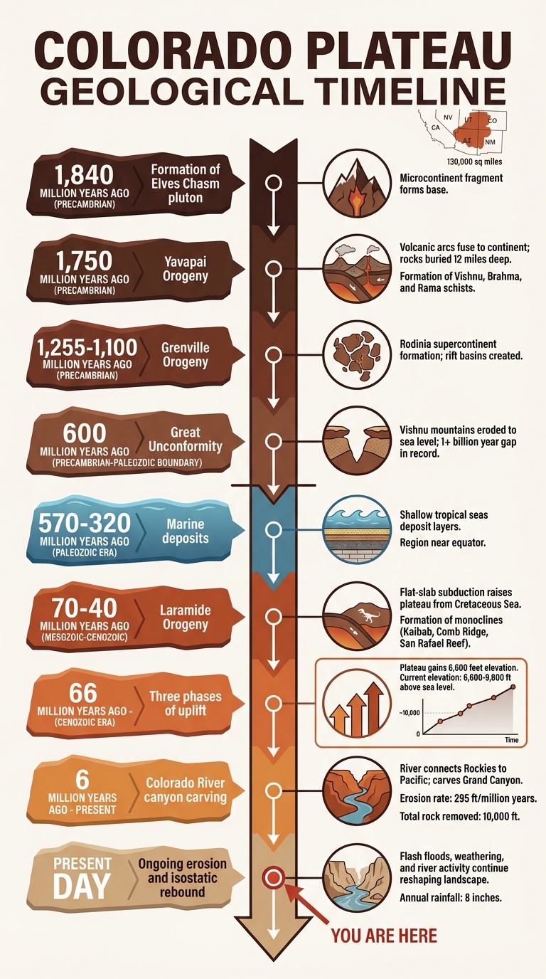
Colorado Plateau Geological Timeline: 2 Billion Years of Formation
The Precambrian Base: Ancient Beginnings
Formation of Basement Rocks
The origins of the Colorado Plateau trace back nearly 2 billion years, starting with the Vishnu Basement Rocks found at the base of the Grand Canyon. These ancient rocks were formed as volcanic island arcs and ocean floor sediments, which collided with the southern edge of ancestral North America between 1,840 and 1,375 million years ago.
The oldest piece of this geological puzzle is the Elves Chasm pluton, dated at 1,840 million years old. This metamorphosed tonalite represents a fragment of a microcontinent that contributed to the expansion of the North American landmass. Around 1,750 million years ago, the Yavapai Orogeny – a significant mountain-building event – fused these volcanic arcs to the continent. During this process, rocks were buried as deep as 12 miles (20 kilometers), undergoing intense pressure and heat that transformed them into the schists we see today.
"The Brahma and Rama schists originated as volcanic rocks, and the Vishnu Schist as sedimentary rocks. These rocks were deposited in volcanic island arcs that were later welded to the growing continent in the Yavapai orogeny." – National Park Service
The basement rocks consist of three main metamorphic units: the Vishnu Schist (originally submarine sediments), the Brahma Schist (metamorphosed volcanic material), and the Rama Schist (altered felsic volcanic rocks). Intruding these schists is the Zoroaster Plutonic Complex, a network of granite and granodiorite that formed as magma chambers beneath volcanic islands between 1,740 and 1,713 million years ago. Together, these formations cover an impressive 465 million years of history.
The Grenville Orogeny
The basement rocks faced additional tectonic forces during the Grenville Orogeny, a major mountain-building event that occurred between roughly 1,255 and 1,100 million years ago. This event was tied to the formation of Rodinia, an ancient supercontinent that brought much of Earth’s landmass together. Unlike the earlier Yavapai Orogeny, the Grenville Orogeny caused deformation within the continent itself, creating rift basins that would later serve as sites for younger rock deposits.
By 600 million years ago, the towering "Vishnu mountains" had been worn down to sea level, leaving behind a smooth crystalline surface. This extensive erosion created the Great Unconformity, a gap in the geological record spanning over a billion years before newer sedimentary layers were deposited on top.
"By 600 million years ago North America had been eroded to a remarkably smooth surface. It is on this crystalline rock surface that the younger, more familiar layered rocks of the Colorado Plateaus were deposited." – National Park Service
This ancient Precambrian foundation laid the groundwork for the dramatic transformations brought by the Paleozoic seas, which would later reshape the landscape of the Colorado Plateau.
sbb-itb-00512f3
Paleozoic Era: Seas Cover the Land
Marine Deposits and Sea Level Changes
Roughly 570 to 320 million years ago, the region now known as the Grand Canyon sat near the equator as part of the North American plate. This prime location fostered a tropical climate, perfect for the formation of shallow marine sediments. During this time, fluctuating global sea levels – driven by tectonic plate activity – caused shallow seas to periodically flood the low-lying continental interior.
"During the Late Cambrian to Late Mississippian, (570 to 320 million years ago), the Grand Canyon region remained stable, while thin sheets of shallow marine sediments were deposited." – Kate Tiedeman, Author
These tropical seas left behind distinct layers of sandstone, mudstone, and limestone, which now form the base of the canyon’s exposed rock layers. These formations, stacked like a geological layer cake, provide a window into the region’s ancient history. Among the oldest Paleozoic rocks here is the early to middle Cambrian Tintic Quartzite, found at Timpanogos Cave National Monument.
| Period | Representative Formations | Environment |
|---|---|---|
| Cambrian | Tintic Quartzite (Timpanogos Cave) | Shallow Marine |
| Mississippian | Rocks in Dinosaur National Monument and Timpanogos Cave | Shallow Marine |
| Pennsylvanian | Units in Arches and Canyonlands | Marine to Marginal Marine |
| Permian | Rocks in Zion, Capitol Reef, and Natural Bridges | Marine to Coastal Desert |
Erosion Between Sea Advances
The region wasn’t always submerged under water. When the seas receded, erosion intensified, stripping away earlier deposits and creating gaps in the geological record. These gaps, known as unconformities, represent times when sediment either wasn’t deposited or was actively worn away. Dinosaur National Monument holds one of the most complete Paleozoic records in the area, with rocks from nearly every period except the Silurian.
Mesozoic Era: Mountain Building Begins
The Laramide Orogeny
Around 70 to 40 million years ago, the Colorado Plateau experienced a dramatic geological shift during the Laramide Orogeny. This event pushed tectonic activity nearly 620 miles inland from the western edge of North America [[12]](https://www.lightrainproductions.com/Home Page/Laramide-Orogeny-FAQ.htm).
The driving force? The Farallon Plate, an oceanic plate that subducted beneath the North American Plate. But instead of diving steeply into the mantle, it slid nearly flat – a process called flat-slab subduction. This unusual movement caused widespread uplift far from the plate boundary [[12]](https://www.lightrainproductions.com/Home Page/Laramide-Orogeny-FAQ.htm).
"The Laramide Orogeny is the birth of The Colorado Plateau." – Light Rain Productions [[12]](https://www.lightrainproductions.com/Home Page/Laramide-Orogeny-FAQ.htm)
During the most active phase, between 70 and 50 million years ago, this flat-slab subduction raised the plateau from its position beneath the ancient Cretaceous Sea to a high continental landscape. At the same time, the Rocky Mountains began to rise to the east [[12]](https://www.lightrainproductions.com/Home Page/Laramide-Orogeny-FAQ.htm). This tectonic activity laid the groundwork for the plateau’s unique geological features.
Formation of Structural Features
The uplift caused by the Laramide Orogeny didn’t just raise the land – it twisted and reshaped it. Ancient Precambrian faults buried beneath layers of sediment were reactivated, causing the overlying rock to fold and buckle. This process created striking monoclines – large, step-like bends in the rock layers [[12]](https://www.lightrainproductions.com/Home Page/Laramide-Orogeny-FAQ.htm).
| Feature | Location | Importance |
|---|---|---|
| Kaibab Monocline | Grand Canyon region | Raised the Kaibab Plateau to over 8,000 feet [[12]](https://www.lightrainproductions.com/Home Page/Laramide-Orogeny-FAQ.htm) |
| Comb Ridge | Four Corners region | A prominent ridge marking a deep crustal fault [[12]](https://www.lightrainproductions.com/Home Page/Laramide-Orogeny-FAQ.htm) |
| San Rafael Reef | Central Utah | A jagged monocline formed by the plateau’s rotation [[12]](https://www.lightrainproductions.com/Home Page/Laramide-Orogeny-FAQ.htm) |
These features act as the geological framework of the modern Colorado Plateau. For instance, the Bright Angel Fault in the Grand Canyon, reactivated during this period, later influenced how water carved out the region’s iconic drainage patterns. While the Laramide Orogeny established this structural foundation, the deep canyons we see today were shaped during another uplift event roughly 5 million years ago [[12]](https://www.lightrainproductions.com/Home Page/Laramide-Orogeny-FAQ.htm).
Cenozoic Era: Uplift and Canyon Carving
Phases of Uplift
The Colorado Plateau didn’t rise to its current height all at once. Over 66 million years, it gained about 6,600 feet in elevation through three distinct uplift phases. By the end of the Laramide Orogeny, around 40 million years ago, the plateau had reached about half of its modern height. By the mid-Miocene, approximately 16 million years ago, it stood close to its current elevation of 6,600 to 9,800 feet above sea level.
The latest uplift phase, spanning the last 20 million years, was fueled by mantle upwelling and thermal expansion caused by a thinning lithosphere. Geologist Mousumi Roy from the University of New Mexico explains this process:
"Warming of the thicker, more iron-depleted Colorado Plateau lithosphere over 35–40 Myr following mid-Cenozoic removal of the Farallon plate from beneath North America is the primary mechanism driving rock uplift"
. Additionally, as erosion stripped away surface materials, the lighter crust beneath responded by rising – a phenomenon known as isostatic rebound. This gradual uplift set the stage for the powerful forces of river erosion.
Development of the Colorado River
As the plateau reached its modern elevation, the Colorado River system began to play a major role. By at least 6 million years ago, the river had become a continuous waterway, connecting the Rocky Mountains to the Pacific Ocean and driving rapid canyon erosion. Between 4.80 and 4.63 million years ago, the river reached the Gulf of California, establishing a new base level that accelerated the carving of deep canyons.
The river’s erosive strength comes from its water volume and the sediment it carries. Unlike the clear waters of the Rockies, the softer sedimentary rocks of the plateau generate a high sediment load. This sediment-laden water acts like sandpaper, grinding through rock layers with remarkable efficiency. In the western Grand Canyon, the river has carved downward at an average rate of about 295 feet per million years over the past 600,000 to 4 million years.
Erosion and Canyon Formation
The interplay of uplift and erosion has sculpted the Colorado Plateau’s iconic landscape of canyons and mesas. Since the uplift began, erosion has stripped away an estimated 10,000 feet of rock, with about half of this occurring after the Colorado River integrated around 6 million years ago.
The region’s distinct mesas and buttes owe their formation to escarpment retreat, where cliffs erode backward over time. Hard rock layers act as protective caps, while the softer layers beneath erode more quickly, creating the plateau’s signature stair-step topography. Structural features like the Bright Angel Fault and Kaibab Monocline have also shaped drainage patterns, directing water to carve the deepest channels. During the Pleistocene, with its colder and wetter conditions over the last 2.6 million years, increased precipitation further accelerated the erosion that gave rise to the dramatic canyons we see today.
Modern Landscapes: The Result of Millions of Years
The Plateau’s National Parks
The geological wonders of the Colorado Plateau are on full display in its national parks, which continue to amaze visitors and fuel scientific exploration. This region holds the highest concentration of National Park Service units outside Washington, D.C.. The forces that shaped this plateau over millions of years have created natural masterpieces, showcasing billions of years of Earth’s history and the continuous processes of erosion.
Grand Canyon National Park spans elevations from about 2,000 feet at the Colorado River to over 8,000 feet at the North Rim. Arches National Park is home to the planet’s highest density of natural sandstone arches, formed by the interplay of salt tectonics and weathering. At Bryce Canyon National Park, thousands of hoodoos – tall, thin spires of rock – rise from the Cenozoic-aged Claron Formation. Zion National Park features towering Navajo Sandstone cliffs, some reaching 2,000 feet high, carved by deep slot canyons. Meanwhile, Capitol Reef National Park protects the Waterpocket Fold, a 100-mile-long monocline created during the Laramide Orogeny, between 70 and 50 million years ago.
These parks are more than scenic destinations – they are crucial for geoscientific research. Between 2002 and 2011, paleontological studies uncovered remarkable fossils, such as Jurassic dinosaurs from the Morrison Formation at Dinosaur National Monument and Eocene-era fossils at Fossil Butte National Monument.
Beyond their scientific importance, these parks draw countless outdoor adventurers eager to explore their beauty. For those planning a visit, The National Park Guide (https://thenationalparkguide.com) offers helpful tips and detailed travel information. As visitors learn about Earth’s history, they also witness the ongoing changes in these landscapes, shaped by both natural erosion and human intervention.
Continuing Erosion and Future Changes
The geological evolution of the Colorado Plateau is far from over. Flash floods remain a dominant erosional force in this semi-arid region, which receives just 8 inches of rain annually. These sudden, powerful floods carve through the landscape, transporting sediment through narrow slot canyons like Antelope Canyon near Page, Arizona. This canyon, over 100 feet deep but only a few meters wide, is a striking example of the plateau’s dynamic geology. Meanwhile, frost wedging and chemical weathering gradually erode rock surfaces, and the Colorado River continues to cut deeper into ancient layers of rock.
However, modern dams have significantly altered natural sediment flows. These structures trap sediment that would have traveled the river’s 1,400-mile journey to the Sea of Cortez, changing the water’s color from its original reddish-brown to a clearer green. To address this, the U.S. government conducted a controlled flood from Glen Canyon Dam in March 1996, a 12-day experiment aimed at restoring sandbars and beaches. The success of this effort has led to plans for similar floods every 5 to 10 years.
As erosion persists, isostatic rebound – where the Earth’s crust rises in response to reduced pressure – may lead to further uplift of the plateau, ensuring that its transformation continues. The Colorado Plateau remains a living landscape, constantly reshaped by both natural forces and human activity.
How the Colorado Plateau Formed & Rose 8,500 Feet
Conclusion
Stretching back nearly 2 billion years, the story of the Colorado Plateau begins with its Precambrian crystalline basement. Covering around 130,000 square miles, this region has witnessed an incredible geological journey: repeated marine submersions during the Paleozoic, a shift to desert landscapes in the Mesozoic, and uplift during the Laramide Orogeny between 70 and 40 million years ago . Unlike the surrounding areas that experienced extensive deformation, the plateau’s sedimentary layers have remained largely intact, creating its iconic layered look. Elevations across the plateau vary dramatically, from canyon floors around 2,000 feet to peaks soaring close to 13,000 feet.
"This region is one of the world’s premier natural showcases for Earth history." – National Park Service
The forces that shaped the plateau are still at work today. The Colorado River continues to carve through ancient rock, while weathering processes refine the landscape. This remarkable geology has given rise to some of the nation’s most cherished protected areas, including Grand Canyon, Zion, Bryce Canyon, Arches, and Capitol Reef National Parks. If you’re planning a visit to these breathtaking sites, resources like The National Park Guide (https://thenationalparkguide.com) can help you make the most of your adventure. The Colorado Plateau not only tells the story of Earth’s dynamic past but also invites us to marvel at its ever-changing beauty.
FAQs
Why is the Colorado Plateau so stable compared to nearby regions?
The Colorado Plateau owes its stability to its location on a massive, rigid block of Earth’s crust that resists bending or breaking. While surrounding regions have experienced significant tectonic activity, this area has remained relatively steady throughout the Cenozoic era. Its gradual uplift is attributed to internal forces such as magmatic activity and changes within the lithosphere. This unique combination allows the plateau to rise without undergoing the dramatic crustal deformation seen in neighboring, more tectonically active zones.
What is the Great Unconformity, and why does it matter here?
The Great Unconformity represents a massive missing piece in Earth’s geological timeline, where erosion stripped away layers of rock, effectively erasing millions of years of history. This phenomenon is particularly relevant here as it underscores the immense geological processes – like uplift and erosion – that have played a crucial role in shaping the Colorado Plateau over countless millennia.
How did uplift and the Colorado River work together to carve the Grand Canyon?
The Grand Canyon owes its breathtaking form to the combined forces of the Colorado Plateau’s uplift and the relentless erosion by the Colorado River over millions of years. Tectonic movements elevated the plateau, steepening the river’s slope and enabling it to carve deeply into the rock layers. Over time, erosion – helped along by weathering processes like freeze-thaw cycles – expanded the canyon, revealing its rich geological history and giving it the iconic stepped structure we see today.