
Chiricahua National Park is one of Arizona’s most unusual landscapes, with towering volcanic rock spires, narrow canyons, and balanced boulders scattered across the Chiricahua Mountains. Located about 37 miles southeast of Willcox, the park rewards visitors who enjoy hiking, scenic drives, wildlife, and the outdoors without the crowds of larger destinations.
On October 20, 2026, Chiricahua officially became a national park, following the signing of the Chiricahua National Park Act. The redesignation recognizes the area’s remarkable geological formations, biodiversity, and cultural heritage.
For a first visit, I’d recommend planning around three experiences:
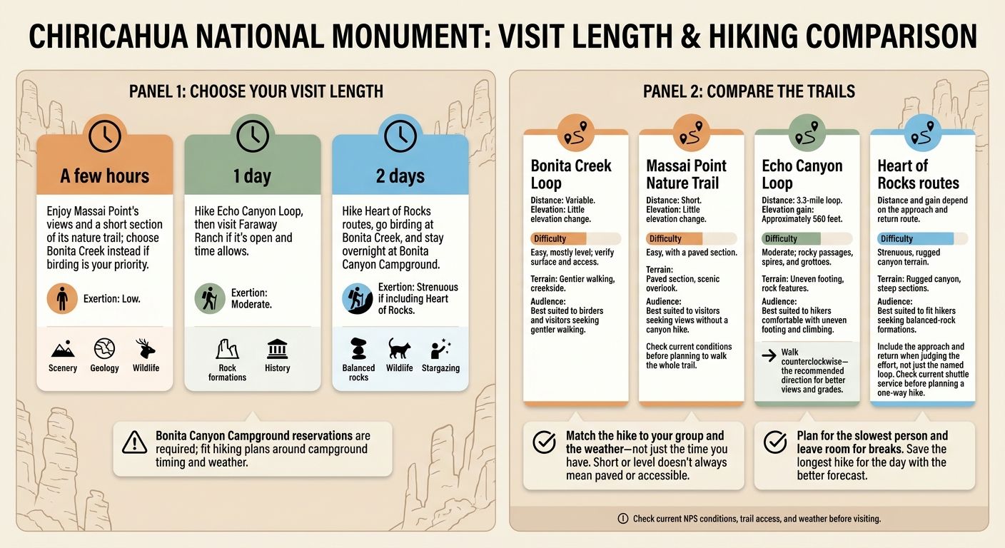
- A few hours: Drive the 8-mile Bonita Canyon scenic road and explore the viewpoints around Massai Point.
- One full day: Hike Echo Canyon Loop, explore the volcanic rock formations, and stop at Faraway Ranch.
- Two days: Add the strenuous Heart of Rocks hike, spend more time birdwatching, and camp beneath the stars at Bonita Canyon.
The biggest planning consideration is choosing trails that match your abilities. Chiricahua’s hiking routes can be surprisingly demanding, with steep rock steps, changing elevations, and exposed terrain.
Chiricahua National Park at a Glance
| Planning detail | What to know |
|---|---|
| Location | Chiricahua Mountains, southeastern Arizona |
| Nearest supply towns | Willcox and Sunizona |
| Recommended visit | A few hours to 2 days |
| Scenic drive | 8 miles one way to Massai Point |
| Best hiking seasons | Spring and fall |
| Entrance fee | Free as of October 2026 |
| Entrance reservation | Not required |
| Camping | Bonita Canyon Campground; reservations required |
| Visitor center | Usually 8:30 AM–4:30 PM, Arizona MST |
| Pet access | Limited to designated lower-elevation trails and developed areas |
Before you arrive: Fill your gas tank, bring food and drinking water, and download maps for offline use. Services and cellular reception are limited near the park.
Check the official Chiricahua National Park website for current road conditions, closures, and visitor information.
sbb-itb-00512f3
Getting to Chiricahua National Park
Chiricahua is located in southeastern Arizona, surrounded by the mountains and grasslands of Cochise County.
Most visitors approach through Willcox, which is also the most practical place to purchase supplies or arrange overnight lodging outside the park.
Driving Directions from Willcox
From Interstate 10, enter Willcox and follow Arizona Highway 186 south for approximately 32 miles. Turn left onto Highway 181 and continue about 4 miles to the park.
The route is paved, although sections are winding and require slower driving.
Visitors approaching from the southwest can use Highway 181 through Sunizona.
Avoid assuming every mapped shortcut is suitable for your vehicle. Roads approaching from other directions, including Pinery Canyon Road, may be unpaved, rough, or unsuitable after rain or snow.
For current directions, consult the NPS transportation guide.
Bonita Canyon Scenic Drive and Vehicle Restrictions
Bonita Canyon Drive is the park’s main scenic road. It climbs approximately 8 miles from the entrance area to Massai Point, passing the visitor center, forested canyons, and access points for several hiking trails.
It’s worth allowing at least 1–2 hours for the drive and viewpoints, longer if you plan to walk any of the trails.
The road is paved but narrow, with curves and limited turnaround opportunities.
RV and Trailer Warning
Vehicles longer than 24 feet and all trailers are prohibited beyond Bonita Canyon Campground. Other restrictions apply near Faraway Ranch, the visitor center, and the lower parking areas. Visitors driving large vehicles should review NPS regulations before entering the park.
| Road or parking area | Vehicle restriction |
|---|---|
| Faraway Ranch and visitor center | Designated parking for certain vehicles 24–29 feet long |
| Faraway Ranch to Bonita Canyon Campground | Maximum vehicle length: 29 feet |
| Bonita Canyon Campground | Maximum individual RV or trailer length: 29 feet; campsite dimensions also apply |
| Beyond Bonita Canyon Campground to Massai Point | Maximum vehicle length: 24 feet; trailers prohibited |
| Echo Canyon, Sugarloaf, Natural Bridge, Massai Point, and Bonita Creek parking | Vehicles over 24 feet and trailers prohibited under park regulations |
| Day-use trailers | Must remain at Faraway Ranch paved parking; trailers without campground reservations must be disconnected there |
If you’re towing a camper, check both the vehicle length restrictions and the driveway dimensions of your reserved campsite.
A smaller passenger vehicle is the most practical option for exploring the upper scenic road.
Official reference: NPS Laws and Policies
Visitor Center and Park Facilities
The Chiricahua Visitor Center is approximately 2 miles inside the park entrance.
Stop here to pick up maps, learn about the area’s geology and human history, and speak with staff about current hiking conditions.
The center includes exhibits, a park film, restrooms, and a store. Regular operating hours are 8:30 AM to 4:30 PM, except for certain holidays.
Drinking water is available at developed facilities, but many trailheads have no water supply.
Best Time to Visit Chiricahua National Park
Spring and fall are generally the best seasons for hiking Chiricahua’s longer trails. Temperatures are often comfortable during the day, although colder conditions are possible at higher elevations.
Summer brings monsoon thunderstorms, while winter can bring snow and ice.
| Season | Conditions | Best experiences |
|---|---|---|
| Spring (March–May) | Mild to warm days, cooler nights, possible wildflowers | Longer hikes, photography, birdwatching |
| Summer (June–August) | Warm days, strong sun, thunderstorms during monsoon season | Early hikes and shorter scenic stops |
| Fall (September–November) | Generally cooler hiking conditions; storms still possible in early fall | Echo Canyon, Heart of Rocks, camping |
| Winter (December–February) | Cold nights, occasional snow and icy trails | Scenic views, photography, hiking when conditions allow |
Visiting During Monsoon Season
Monsoon season generally lasts from mid-June through September.
Thunderstorms can develop quickly over the Chiricahua Mountains, bringing lightning, heavy rainfall, and flash flooding.
Plan longer hikes early in the day when forecasts indicate a chance of afternoon storms. Avoid narrow washes and exposed ridges when thunderstorms threaten.
Visiting During Winter
Chiricahua’s elevation makes it considerably cooler than many lower desert destinations in Arizona.
The visitor center sits around 5,400 feet, while Massai Point reaches approximately 6,870 feet.
Snow and ice can temporarily close the upper scenic road or make rocky hiking trails difficult.
My recommendation: If hiking is the focus of your visit, target April, May, October, or November, but always check the forecast and current conditions rather than relying on the season alone.
Best Things to Do in Chiricahua National Park
Chiricahua’s main attractions are concentrated along Bonita Canyon Drive and its connected hiking trails.
The park is especially rewarding for visitors interested in geology, mountain scenery, wildlife, and photography.
1. Drive to Massai Point for the Best Scenic Views
Massai Point sits near the end of Bonita Canyon Drive and is one of the best places to appreciate the park’s unusual volcanic formations.
From the overlook, visitors can see clusters of rhyolite pinnacles rising above the forested canyons. Interpretive displays explain how ancient volcanic activity and erosion shaped the landscape.
The 0.5-mile Massai Point Nature Trail provides additional viewpoints.
Why visit: The combination of scenic overlooks and a short interpretive trail makes Massai Point a strong choice for nearly every first-time visitor.
How much time to allow: Approximately 30–60 minutes, depending on how much of the trail you explore.
The northern 0.1-mile section is paved but steep. The remainder includes steps and uneven surfaces.
2. Hike Echo Canyon Loop Through the Wonderland of Rocks
The Echo Canyon Loop is one of the best ways to experience Chiricahua’s rock formations up close.
The approximately 3.4-mile route combines the Echo Canyon, Hailstone, and Ed Riggs trails.
Along the way, hikers pass narrow rock corridors, volcanic pinnacles, unusual boulders, and scenic canyon overlooks.
One of the highlights is the Grotto, where enormous rocks create a series of passageways and sheltered spaces.
Why visit: Echo Canyon delivers much of the park’s signature scenery without requiring an all-day hike.
The National Park Service recommends walking the loop counterclockwise for the views and elevation changes.
Expect rocky footing, steps, and approximately 560 feet of total elevation change.
Allow 2–4 hours to complete the loop.
3. Explore the Heart of Rocks
The Heart of Rocks Loop is one of Chiricahua’s most rewarding and demanding hikes.
The full outing is approximately 7.3–7.4 miles round trip, depending on the route and NPS source.
The destination is a collection of remarkable formations, including Big Balanced Rock and Pinnacle Balanced Rock.
Getting there requires a substantial approach hike with elevation changes, rocky steps, and rugged terrain.
Why visit: Heart of Rocks is ideal for experienced hikers who want to explore deeper into Chiricahua’s wilderness and see formations that cannot be reached by car.
Allow approximately 4–6 hours, potentially longer for frequent breaks and photography.
NPS recommends following the named Heart of Rocks loop clockwise.
4. Go Birdwatching Along Bonita Creek
Bonita Creek Loop offers a completely different experience from the rocky upper trails.
This 0.2-mile paved route passes through lower-elevation vegetation and provides opportunities to observe birds and other wildlife.
Chiricahua’s location between desert and mountain ecosystems supports an unusually diverse range of plant and animal species.
Why visit: Bonita Creek is a good choice for a short nature walk, birdwatching, and visitors who prefer gentler terrain.
Its paved surface also makes it one of the park’s most accessible outdoor experiences.
5. Discover the History of Faraway Ranch
Faraway Ranch preserves an important part of the area’s ranching and tourism history.
The property was developed by the Erickson family, who settled in Bonita Canyon during the late 1800s.
Over time, the ranch became a destination for visitors exploring the surrounding mountains and rock formations.
Why visit: Faraway Ranch provides historical context for the park beyond its geological scenery.
Visitors can explore permitted outdoor areas, with interior access and tours depending on park operations.
The park also preserves a broader cultural history connected to the Chiricahua Apache, Buffalo Soldiers, and earlier communities.
Best Hiking Trails in Chiricahua National Park
Chiricahua offers everything from short paved walks to strenuous hikes through rugged volcanic terrain.
The best trail depends on how much time you have, how comfortable you are with rocky footing, and whether you want panoramic views or close-up encounters with the formations.
Hiking Trails by Difficulty
| Trail | Distance | Difficulty | Highlights |
|---|---|---|---|
| Bonita Creek Loop | 0.2 mile | Easy | Birdwatching, paved trail, wildlife |
| Massai Point Nature Trail | 0.5 mile | Easy–moderate | Rock pinnacles, interpretive views |
| Echo Canyon Loop | About 3.4 miles | Moderate | Grotto, canyon passages, volcanic rocks |
| Heart of Rocks Loop route | About 7.4 miles | Strenuous | Balanced rocks, remote formations |
| Sugarloaf Mountain Trail | 1.8 miles round trip | Moderate–strenuous | High-elevation views, historic lookout |
| Natural Bridge Trail | 4.7 miles round trip | Strenuous | Backcountry terrain and a natural rock bridge |
Distances are approximate. NPS trail pages and printed hiking guides sometimes use slightly different measurements. Confirm the route and current conditions before hiking.
Echo Canyon vs. Heart of Rocks: Which Should You Choose?
For first-time visitors, Echo Canyon is my recommendation.
You get the narrow passages, impressive pinnacles, and close-up rock formations that make Chiricahua distinctive, without dedicating most of the day to hiking.
Choose Heart of Rocks when you have more time, stronger hiking experience, and want to see some of the park’s most unusual balanced formations.
| Consideration | Echo Canyon | Heart of Rocks |
|---|---|---|
| Hiking time | 2–4 hours | 4–6+ hours |
| Difficulty | Moderate | Strenuous |
| Main attraction | Grotto and dramatic rock corridors | Balanced rock formations |
| Best for | First-time visitors and recreational hikers | Fit, experienced hikers |
| Planning commitment | Half-day hike | Major hiking objective |
A shorter alternative: If you want a taste of Echo Canyon without completing the full loop, consider hiking partway toward the Grotto and turning around. NPS describes an approximately 1.2-mile round-trip option, subject to trail conditions.
Need help comparing hiking routes? Use our National Park Trail Finder or Hiking Difficulty Calculator to evaluate trails by distance, difficulty, and your abilities.
Chiricahua National Park Itineraries
The amount of time you spend at Chiricahua determines how deeply you can explore the park.
The scenic road and overlooks make a short visit worthwhile, but an overnight stay gives you more flexibility for longer hikes.
A Few Hours: Scenic Drive and Massai Point
Best for: Road trippers, families, photographers, and visitors with limited time.
Suggested time: Approximately 2–3 hours inside the park.
- Start at the visitor center. Pick up a map and check whether the upper road is open.
- Drive Bonita Canyon Road. Enjoy the changing landscape as the road climbs toward the rock formations.
- Explore Massai Point. Take in the overlooks and walk a comfortable section of the nature trail.
- Add Bonita Creek if time permits. Enjoy a short walk or look for birds in the lower canyon.
This itinerary works well for visitors who prefer sightseeing over strenuous hiking.
One Day: Echo Canyon and Historic Chiricahua
Best for: First-time visitors who want the park’s signature hiking experience.
Suggested time: Approximately 5–7 hours, excluding travel to the park.
Morning — Echo Canyon Loop
Arrive early and begin the 3.4-mile Echo Canyon Loop. Allow plenty of time to explore the Grotto and stop for photographs.
Midday — Picnic and Massai Point
After hiking, visit Massai Point for panoramic views of the rock formations you explored on foot.
Enjoy a packed lunch at a designated picnic area.
Afternoon — Faraway Ranch
Return toward the lower park and explore Faraway Ranch’s permitted outdoor areas.
This provides a different perspective on Chiricahua through its cultural and historical resources.
If rain or thunderstorms threaten the upper trails, replace the hike with shorter scenic stops where conditions are safe.
Two Days: Hiking, Wildlife, and Camping
Best for: Active travelers, couples, photographers, and visitors interested in longer hikes.
Day 1 — Explore the Main Attractions
Spend the morning hiking Echo Canyon Loop.
During the afternoon, stop at Massai Point, visit Faraway Ranch, and enjoy the Bonita Creek area.
Check into Bonita Canyon Campground and spend the evening enjoying the quieter setting.
Day 2 — Heart of Rocks
Begin early for the strenuous Heart of Rocks hike.
Allow most of the morning and early afternoon for the route, including breaks, navigation, and photography.
Return to your vehicle with enough daylight to complete the drive safely.
Planning advice: Schedule your longest hike for the day with the better weather forecast. Don’t build an itinerary around completing both major hikes if your group would be more comfortable with one.
You can also use our National Park Itinerary Generator to organize a trip around your travel dates, group, and preferred activities.
Camping at Chiricahua National Park
Bonita Canyon Campground is the park’s established campground and provides a convenient base for exploring the trails and scenic road.
The campground sits among mature trees at approximately 5,400 feet, creating a cooler environment than many lower-elevation Arizona camping destinations.
Bonita Canyon Campground Reservations and Amenities
The campground has 25 individual campsites and a separate group camping area.
Advance reservations are required through Recreation.gov.
Individual sites are currently listed at $25 per night, with a separate rate for the group site. Verify rates and availability before booking.
Campground facilities include:
- Flush toilets and potable drinking water.
- Picnic tables, designated grills, and shared food-storage lockers.
- Accessible facilities and a designated accessible campsite.
- No showers or standard RV utility hookups.
- Limited campsite dimensions and a maximum individual vehicle or trailer length of 29 feet.
Campers must observe the campground’s posted fire regulations. Ground fires are prohibited, and seasonal fire restrictions may limit the use of designated grills.
Reservation tip: The campground can fill during popular spring and fall travel periods. Some sites may also close during the summer monsoon season because of flood risk.
Check the official Bonita Canyon Campground information before making plans.
Can You Camp in Chiricahua’s Backcountry?
Ordinary overnight camping is restricted to established campsites at Bonita Canyon Campground.
Camping elsewhere in the park, including the backcountry, requires written permission from the superintendent.
Do not assume that backcountry camping is generally available or that an overnight wilderness trip can be arranged without special authorization.
For other camping options, check the surrounding Coronado National Forest, where different camping rules apply.
Visiting Chiricahua National Park With Dogs
Dogs are allowed in parts of Chiricahua National Park, but most of the upper-elevation hiking trails prohibit pets.
This is important when choosing your itinerary.
Pet Access Warning
Dogs are not permitted on Echo Canyon, Massai Point Nature Trail, Heart of Rocks, Sugarloaf, Natural Bridge, or other trails above 5,500 feet. The restriction also applies to pets being carried.
Where Are Dogs Allowed?
Leashed pets are allowed in designated areas, including:
- Bonita Canyon Campground.
- Paved parking areas.
- Bonita Creek Trail.
- Silver Spur Meadow Trail.
- Faraway Ranch area and designated lower trails.
- The designated trail connection between the campground and visitor center.
Pets must remain on a leash no longer than 6 feet. Owners must collect pet waste, keep animals away from wildlife, and never leave pets unattended.
My recommendation: If you want to explore Echo Canyon or Heart of Rocks, arrange appropriate care for your dog rather than expecting to bring them on the hike.
Review the NPS pet regulations before visiting.
Accessibility at Chiricahua National Park
Chiricahua’s rugged terrain makes many trails unsuitable for wheelchairs or other wheeled mobility devices.
However, several developed areas provide more accessible options.
Accessible Facilities and Trails
Bonita Creek Loop is the park’s most accessible hiking route. The 0.2-mile paved trail has relatively level terrain and offers opportunities for wildlife viewing.
The visitor center and nearby restrooms are accessible, although the building doors do not have automatic openers.
At Massai Point, approximately 0.1 mile of trail is paved, but the steep grade and exposed edges may require powered mobility equipment or assistance. The complete nature trail is not wheelchair accessible.
The area around Faraway Ranch House is accessible to many visitors using mobility devices, although access inside the historic building should be confirmed with park staff.
Bonita Canyon Campground includes an accessible campsite, site 8, and accessible restroom facilities.
For more detailed information, consult the NPS accessibility guide.
Hiking Safety and Weather Preparation
Chiricahua’s trails combine high elevation, rocky surfaces, exposed terrain, and weather that can change quickly.
Preparation is especially important for visitors hiking Echo Canyon, Heart of Rocks, or longer wilderness routes.
Weather and Elevation Warning
The upper hiking areas are cooler and more exposed than the park entrance. Summer lightning, heavy rainfall, and winter ice can make otherwise manageable trails dangerous. Avoid exposed ridges during thunderstorms and never enter washes during flash-flood conditions.
What to Bring for a Day at Chiricahua
- Drinking water and electrolytes: Carry enough for your hike and expected conditions. Plan for approximately a gallon per person per day in warm weather, adjusting for exertion and individual needs.
- Sturdy hiking shoes: Rocky passages, uneven steps, and loose surfaces make good traction important.
- Sun protection and layers: High-elevation sun exposure can be strong even when temperatures are comfortable.
- Offline navigation: Download the park map or carry a paper copy.
- Emergency supplies: Bring a headlamp, food, and a wilderness first-aid kit.
Longer hikes may descend significantly before climbing back toward the trailhead. Save time and energy for the return.
Respect wildlife, store food securely, and remain on established trails. Climbing the rock pinnacles is prohibited.
Before setting out, check the official hiking guide and map.
Frequently Asked Questions About Chiricahua National Park
Is Chiricahua officially a national park?
Yes. Chiricahua was redesignated as Chiricahua National Park on October 20, 2026, after previously being known as Chiricahua National Monument.
The redesignation recognizes its nationally significant geological, ecological, and cultural resources.
Some older NPS pages, maps, and publications may still use the previous name during the transition.
Is there an entrance fee for Chiricahua National Park?
As of October 2026, the National Park Service lists no entrance or parking fee. A timed-entry reservation is also not required.
Campground reservations are separate and involve a fee.
Check the official NPS fees page for changes.
How much time do you need at Chiricahua National Park?
Plan 2–3 hours for the scenic drive, Massai Point, and brief stops.
A full day allows enough time for Echo Canyon Loop and additional sightseeing.
Two days is a better choice if you want to hike Heart of Rocks, go birdwatching, or stay overnight.
Is Chiricahua National Park worth visiting without hiking?
Yes. The scenic drive to Massai Point offers impressive views of the rhyolite formations without requiring a long hike.
Accessible developed areas, interpretive exhibits, and historic sites also provide opportunities to enjoy the park.
Does Chiricahua National Park have a shuttle?
Hiker transportation has been offered intermittently, typically during busy periods, but service depends on staffing, weather, and scheduling.
The park has also suspended shuttle operations at times. Do not plan a one-way hike without confirming current service.
Use the NPS hiking page for the latest information.
What is the best hike at Chiricahua National Park?
Echo Canyon Loop is the best starting point for many first-time visitors. The approximately 3.4-mile loop takes hikers among the park’s famous rock spires, narrow passages, and the Grotto.
Experienced hikers with more time may prefer Heart of Rocks for its unusual balanced formations and more demanding terrain.
Are there bears or other dangerous animals at Chiricahua?
Black bears, mountain lions, javelinas, coatis, and other wildlife inhabit the region.
Sightings vary, and visitors should maintain distance from all wildlife, secure food, and never feed animals.
Stay attentive on the trails, particularly in areas with dense vegetation or limited visibility.
Can I visit Chiricahua National Park in winter?
Yes. The park is generally open year-round, including its scenic road and hiking trails.
However, snow, ice, freezing temperatures, and temporary road closures can affect access to higher elevations.
Check current conditions before traveling.
Plan Your Visit to Chiricahua National Park
Chiricahua offers a different kind of Arizona national park experience. Instead of vast desert overlooks or crowded canyon trails, visitors explore a mountain landscape shaped by ancient volcanic eruptions, where rock spires rise from the forests and grasslands.
For a first visit, prioritize the scenic drive and Massai Point. Add Echo Canyon if you have time for a moderate hike, or spend a second day exploring Heart of Rocks.
The key is giving yourself enough time to experience the landscape rather than rushing between attractions.
Start with the trails and experiences that interest you most, then build the rest of your visit around them.
Use The National Park Guide’s free travel planning tools to compare hikes, organize your itinerary, and prepare for your next national park adventure.
Planning disclaimer: The National Park Guide is an independent travel resource and is not affiliated with the National Park Service. Regulations, fees, trail access, campground availability, and operating schedules may change. Always verify important details with the National Park Service before visiting.